import xarray as xr
import numpy as np
import cartopy.crs as ccrs
import cartopy.feature as cfeature
import matplotlib
from matplotlib import pyplot as plt
from cartopy.mpl.gridliner import LATITUDE_FORMATTER, LONGITUDE_FORMATTER
from metpy.plots import add_timestamp, colortables
from metpy.plots.ctables import registry
import datetime
import datetime as dtMaestro data manipulation
Reprojection de données géostationnaires
Les fichiers netcdf des données de l’imageur SEVIRI (embarqué sur Meteosat 10 pour la position MSG+0000) et téléchargés via le SATMOS possèdent des coordonnées X,Y projetées en mètres. Or, souvent la recherche de coordonnées se fait en lat/lon.
La reprojection des fichiers est possible. Autrement, ce notebook montre comment utiliser le fichier de navigation de MSG+0000 afin de retrouver les coordonnées lat/lon correspondantes aux pixels du fichier de données msg.
Les fichiers de MSG sont aussi disponibles chez ICARE.
J. TRULES pour MAESTRO
catalog_url = "https://thredds-x.ipsl.fr/thredds/catalog/MAESTRO/SATELLITES/MSG/2024/2024_09_10/catalog.html"
opendap_url = "https://thredds-x.ipsl.fr/thredds/dodsC/MAESTRO/SATELLITES/MSG/2024/2024_09_10/"
navig_url = "https://thredds-x.ipsl.fr/thredds/dodsC/MAESTRO/SATELLITES/test/MSG+0000.3km.nc"
navig = "MSG+0000.3km.nc"
file = "Mmultic3kmNC4_msg03_202409101800.nc"Determiner quels sont les pixels correspondants aux lat,lon recherchés
Pour la campagne MAESTRO un CROP était nécessaire pour le partage vers le logiciel de l’ATR42. La zone était carré avec les points suivants (Bas gauche : Lon -4.37753 Lat 39.38261 — Haut droite : Lon 7.118742 Lat 47.717034)
sur le plot suivant, on va visualiser toutes le latitudes sur la colonne 1854, qui correspond au milieu du tableau donc à ~ 0° en longitude
ds_navig.Latitude.loc[:,1854].plot()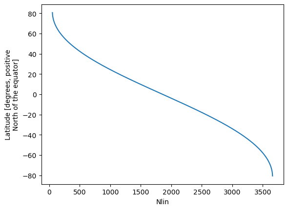
si on va a l’extremité du tableau, la plage diminue
ds_navig.Latitude.loc[:,3554].plot()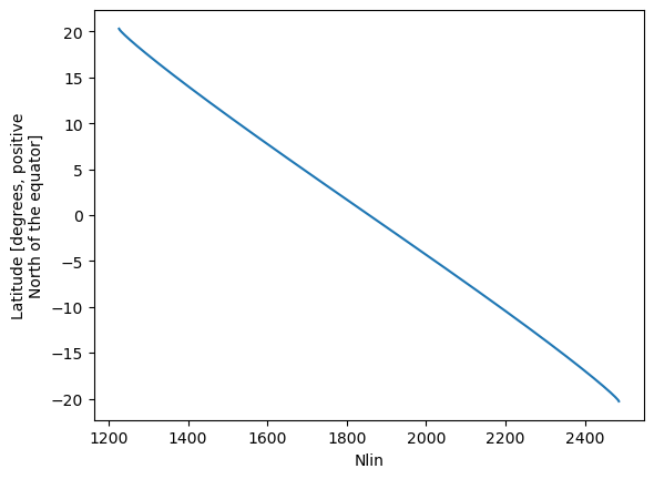
On va filtrer les indices selon les lat/lon désirées
ds_filt = ds_navig.where( (ds_navig.Latitude > 13.4) & (ds_navig.Latitude < 20.1) & (ds_navig.Longitude > -26.4) & (ds_navig.Longitude < -19.47),drop=True)Il faut d’abord assigner les pixels en tant que dimensions puis renommer ces dimensions afi d’être compatibles avec celles du fichier de données satellies (TB)
ds_navig_renamed=ds_navig.assign_coords({"Nlin":("Nlin", ds_navig.Nlin.data),"Ncol":("Ncol", ds_navig.Ncol.data)}).rename_dims({'Nlin':'ny','Ncol':'nx'})
ds_navig_renamed
<xarray.Dataset> Size: 551MB
Dimensions: (ny: 3712, nx: 3712)
Coordinates:
* Nlin (ny) int64 30kB 0 1 2 3 4 5 ... 3707 3708 3709 3710 3711
* Ncol (nx) int64 30kB 0 1 2 3 4 5 ... 3707 3708 3709 3710 3711
Dimensions without coordinates: ny, nx
Data variables:
Latitude (ny, nx) float64 110MB nan nan nan nan ... nan nan nan nan
Longitude (ny, nx) float64 110MB nan nan nan nan ... nan nan nan nan
View_Zenith (ny, nx) float64 110MB ...
View_Azimuth (ny, nx) float64 110MB ...
Pixel_Area_Size (ny, nx) float64 110MB ...
Attributes: (12/26)
Product_Version: 1.0
Production_Date: 2013-07-09T14:52:20Z
Software_Version: 1.0.1
Production_Center: ICARE Data and Services Center
Contact: contact@icare.univ-lille1.fr
Ancillary_Files: None
... ...
creation_date: mar. avril 11 10:26:41 CEST 2017
NCL_Version: 6.1.2
system: Linux camelot.ipsl.polytechnique.fr 2.6.32-431....
Conventions: None
hdf_source: MSG+0000.3km.hdf
title: NCL: convert-HDF-to-netCDFds_filt = ds_navig_renamed.where( (ds_navig_renamed.Latitude > 13.4) & (ds_navig_renamed.Latitude < 20.1) & (ds_navig_renamed.Longitude > -26.4) & (ds_navig_renamed.Longitude < -19.47),drop=True)
ds_filt<xarray.Dataset> Size: 2MB
Dimensions: (ny: 233, nx: 246)
Coordinates:
* Nlin (ny) int64 2kB 1147 1148 1149 1150 ... 1376 1377 1378 1379
* Ncol (nx) int64 2kB 959 960 961 962 963 ... 1201 1202 1203 1204
Dimensions without coordinates: ny, nx
Data variables:
Latitude (ny, nx) float64 459kB nan nan nan nan ... nan nan nan nan
Longitude (ny, nx) float64 459kB nan nan nan nan ... nan nan nan nan
View_Zenith (ny, nx) float64 459kB nan nan nan nan ... nan nan nan nan
View_Azimuth (ny, nx) float64 459kB nan nan nan nan ... nan nan nan nan
Pixel_Area_Size (ny, nx) float64 459kB nan nan nan nan ... nan nan nan nan
Attributes: (12/26)
Product_Version: 1.0
Production_Date: 2013-07-09T14:52:20Z
Software_Version: 1.0.1
Production_Center: ICARE Data and Services Center
Contact: contact@icare.univ-lille1.fr
Ancillary_Files: None
... ...
creation_date: mar. avril 11 10:26:41 CEST 2017
NCL_Version: 6.1.2
system: Linux camelot.ipsl.polytechnique.fr 2.6.32-431....
Conventions: None
hdf_source: MSG+0000.3km.hdf
title: NCL: convert-HDF-to-netCDFOuverture du fichier MSG
ds_msg = xr.open_dataset(opendap_url + file, decode_timedelta=True)ds_msg<xarray.Dataset> Size: 1GB
Dimensions: (ny: 3712, nx: 3712, Numerical_count: 65536)
Dimensions without coordinates: ny, nx, Numerical_count
Data variables: (12/31)
time datetime64[ns] 8B ...
dtime (ny, nx) timedelta64[ns] 110MB ...
IR_016 (ny, nx) float64 110MB ...
commentaires |S64 64B ...
satellite |S64 64B ...
geos |S64 64B ...
... ...
VIS008 (ny, nx) float64 110MB ...
Albedo_to_Native_count_VIS008 (Numerical_count) float32 262kB ...
WV_062 (ny, nx) float64 110MB ...
Temp_to_Native_count_WV_062 (Numerical_count) float32 262kB ...
WV_073 (ny, nx) float64 110MB ...
Temp_to_Native_count_WV_073 (Numerical_count) float32 262kB ...
Attributes: (12/39)
title: Merge many NC3 to one NC4
history: Created on 2024-09-10 18:14 by CMS-Lannion ...
institution: Meteo-France - Centre de Meteorologie Spatiale
source: MSG HRIT File from direct read out
comment: Status experimental
references: none
... ...
Conventions: CF-1.5
ncml_version: 2.2
Rate_of_valid_data: 100.0
Area_of_acquisition: globe
Scanning_direction: south to north
DODS.strlen: 0ds_msg.IR_108.plot()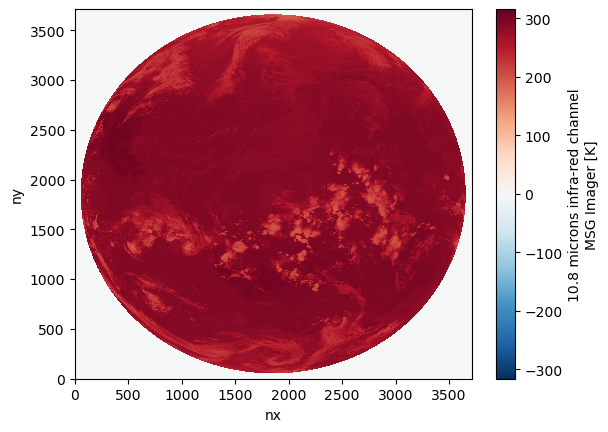
tb_norm, tb_cmap = registry.get_with_steps('ir_rgbv', 0, 1)
fig = plt.figure(figsize=(10, 10))
ax = fig.add_subplot(1, 1, 1, projection=ccrs.Geostationary())
ax.add_feature(cfeature.COASTLINE.with_scale('50m'), linewidth=1)
datRev = ds_msg.IR_108#.T[::-1].T[::-1]
x=ds_msg.X
y=ds_msg.Y
im = ax.imshow(datRev, extent=(x.min(), x.max(), y.min(), y.max()), origin='upper', cmap=tb_cmap)
# start_time = datetime.strptime(ds.start_date_time, '%Y%j%H%M%S')
start_time = dt.datetime.strptime(ds_msg.attrs['time_coverage_start'],'%Y-%m-%dT%H:%M:%SZ%f')
nameSat=ds_msg.attrs['summary']
standard_name = ds_msg['IR_108'].attrs['standard_name']
channel = ds_msg['IR_108'].long_name
add_timestamp(ax, time=start_time, pretext=f'MSG Ch. {channel} ',
              high_contrast=True, fontsize=16, y=0.01)
xlabel = "pixel X"
ylabel = "pixel Y"
plt.xlabel(xlabel)
plt.ylabel(ylabel)
cmapGlob = im.get_cmap()
climGlob = im.get_clim()
#cmap = plt.get_cmap('jet')
fig.colorbar(im, ax=ax).ax.set_title(ds_msg['IR_108'].attrs['standard_name'])
ax.coastlines(resolution='50m', color='black', linewidth=1)
/opt/conda/envs/tmp/lib/python3.12/site-packages/cartopy/io/__init__.py:241: DownloadWarning: Downloading: https://naturalearth.s3.amazonaws.com/50m_physical/ne_50m_coastline.zip
warnings.warn(f'Downloading: {url}', DownloadWarning)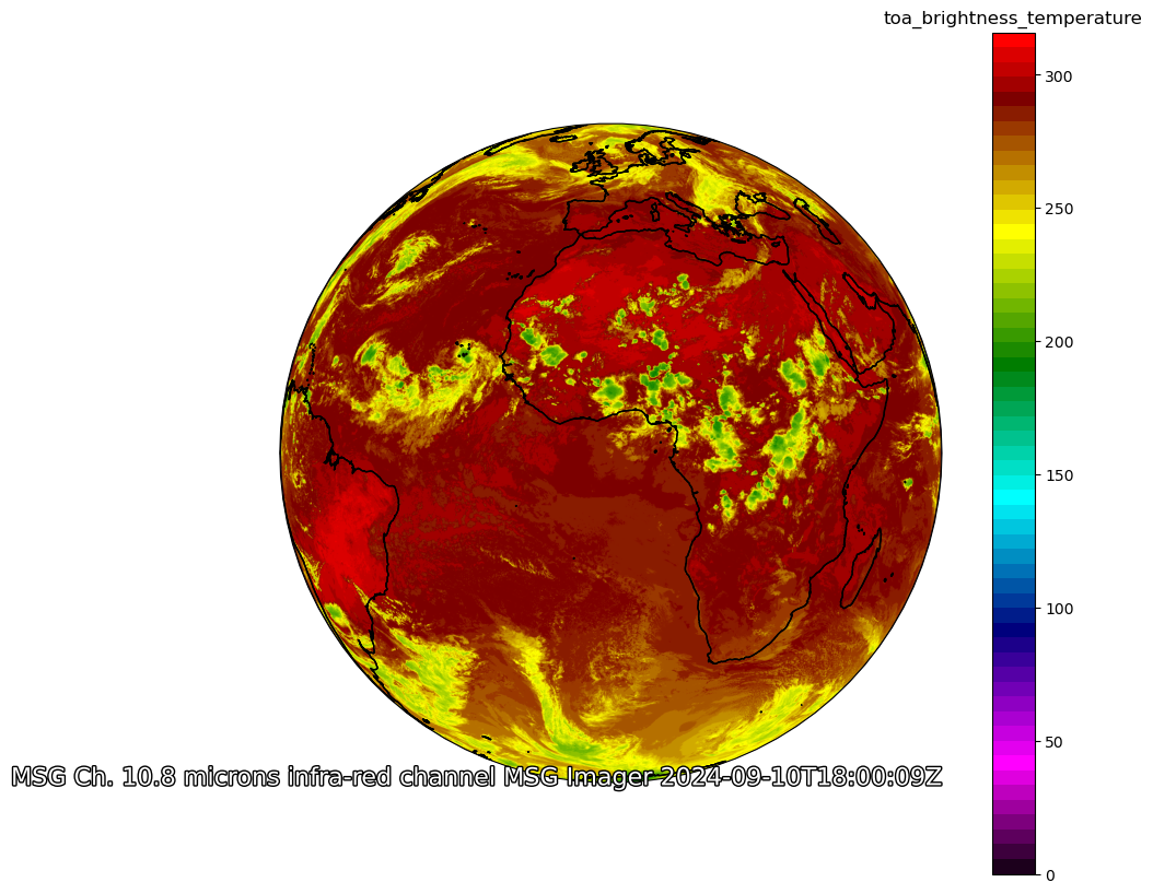
tb_norm, tb_cmap = registry.get_with_steps('ir_rgbv', 0, 1)
fig = plt.figure(figsize=(10, 10))
ax = fig.add_subplot(1, 1, 1, projection=ccrs.Geostationary())
ax.add_feature(cfeature.COASTLINE.with_scale('50m'), linewidth=1)
datRev = ds_msg.IR_108.isel(ny=ds_filt.Nlin,nx=ds_filt.Ncol)
x=ds_msg.isel(ny=ds_filt.Nlin,nx=ds_filt.Ncol).X
y=ds_msg.isel(ny=ds_filt.Nlin,nx=ds_filt.Ncol).Y
#im = ax.imshow(datRev,  origin='upper', cmap=cmapGlob, clim=climGlob)
im = ax.imshow(datRev, extent=(x.min(), x.max(), y.min(), y.max()), origin='upper', cmap=cmapGlob, clim=climGlob)
# start_time = datetime.strptime(ds.start_date_time, '%Y%j%H%M%S')
start_time = dt.datetime.strptime(ds_msg.attrs['time_coverage_start'],'%Y-%m-%dT%H:%M:%SZ%f')
nameSat=ds_msg.attrs['summary']
standard_name = ds_msg['IR_108'].attrs['standard_name']
channel = ds_msg['IR_108'].long_name
add_timestamp(ax, time=start_time, pretext=f'MSG Ch. {channel} ',
              high_contrast=True, fontsize=16, y=0.01)
xlabel = "pixel X"
ylabel = "pixel Y"
plt.xlabel(xlabel)
plt.ylabel(ylabel)
#cmap = plt.get_cmap('jet')
fig.colorbar(im, ax=ax).ax.set_title(ds_msg['IR_108'].attrs['standard_name'])
ax.coastlines(resolution='50m', color='black', linewidth=1)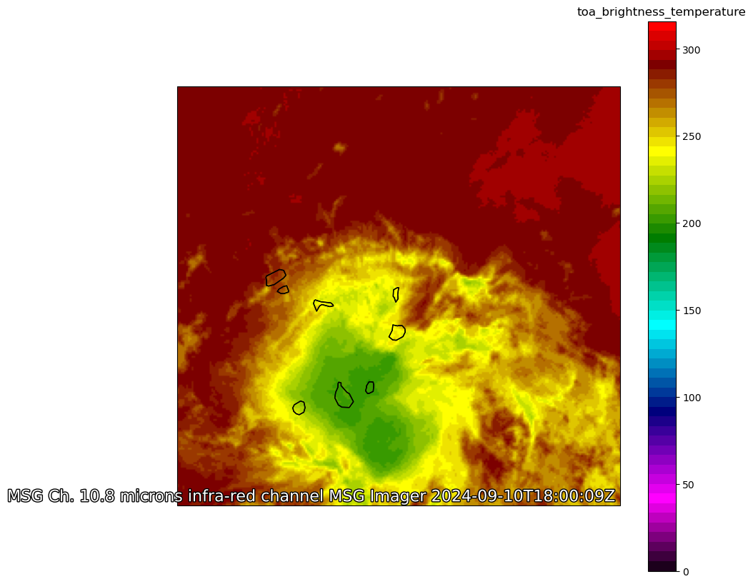
tb_norm, tb_cmap = registry.get_with_steps('ir_rgbv', 0, 1)
fig = plt.figure(figsize=(10, 10))
ax = fig.add_subplot(1, 1, 1, projection=ccrs.Geostationary())
ax.add_feature(cfeature.COASTLINE.with_scale('50m'), linewidth=1)
datRev = ds_msg.IR_108.isel(ny=ds_filt.Nlin,nx=ds_filt.Ncol)
x=ds_msg.isel(ny=ds_filt.Nlin,nx=ds_filt.Ncol).X
y=ds_msg.isel(ny=ds_filt.Nlin,nx=ds_filt.Ncol).Y
im = ax.imshow(datRev, extent=(x.min(), x.max(), y.min(), y.max()), origin='upper', cmap=tb_cmap)
# start_time = datetime.strptime(ds.start_date_time, '%Y%j%H%M%S')
start_time = dt.datetime.strptime(ds_msg.attrs['time_coverage_start'],'%Y-%m-%dT%H:%M:%SZ%f')
nameSat=ds_msg.attrs['summary']
standard_name = ds_msg['IR_108'].attrs['standard_name']
channel = ds_msg['IR_108'].long_name
add_timestamp(ax, time=start_time, pretext=f'MSG Ch. {channel} ',
              high_contrast=True, fontsize=16, y=0.01)
xlabel = "pixel X"
ylabel = "pixel Y"
plt.xlabel(xlabel)
plt.ylabel(ylabel)
#cmap = plt.get_cmap('jet')
fig.colorbar(im, ax=ax).ax.set_title(ds_msg['IR_108'].attrs['standard_name'])
ax.coastlines(resolution='50m', color='black', linewidth=1)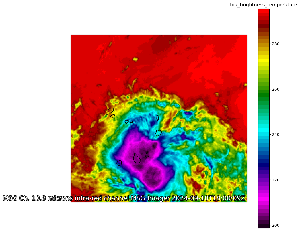
Ci-dessous, le dataset réduit sur la zone
ds_msg.isel(ny=ds_filt.Nlin,nx=ds_filt.Ncol)<xarray.Dataset> Size: 8MB
Dimensions: (ny: 233, nx: 246, Numerical_count: 65536)
Coordinates:
* Nlin (ny) int64 2kB 1147 1148 1149 ... 1378 1379
* Ncol (nx) int64 2kB 959 960 961 ... 1202 1203 1204
Dimensions without coordinates: ny, nx, Numerical_count
Data variables: (12/31)
time datetime64[ns] 8B ...
dtime (ny, nx) timedelta64[ns] 459kB ...
IR_016 (ny, nx) float64 459kB ...
commentaires |S64 64B ...
satellite |S64 64B ...
geos |S64 64B ...
... ...
VIS008 (ny, nx) float64 459kB ...
Albedo_to_Native_count_VIS008 (Numerical_count) float32 262kB ...
WV_062 (ny, nx) float64 459kB ...
Temp_to_Native_count_WV_062 (Numerical_count) float32 262kB ...
WV_073 (ny, nx) float64 459kB ...
Temp_to_Native_count_WV_073 (Numerical_count) float32 262kB ...
Attributes: (12/39)
title: Merge many NC3 to one NC4
history: Created on 2024-09-10 18:14 by CMS-Lannion ...
institution: Meteo-France - Centre de Meteorologie Spatiale
source: MSG HRIT File from direct read out
comment: Status experimental
references: none
... ...
Conventions: CF-1.5
ncml_version: 2.2
Rate_of_valid_data: 100.0
Area_of_acquisition: globe
Scanning_direction: south to north
DODS.strlen: 0ds_msg.close()
ds_navig.close()Lecture des données SENTINEL 5P chez ICARE
from owslib.wms import WebMapServicewms = WebMapService('https://thredds.icare.univ-lille.fr/thredds/wms/S5P_AER-AI_OFFL_D3/2024/S5P_AER-AI_OFFL_D3_2024-09-10_3600x1800_V1-01.nc', version='1.1.1')
wms<owslib.map.wms111.WebMapService_1_1_1 at 0x7f63d277a150>list(wms.contents)['aerosol_index_340_380', 'aerosol_index_354_388']img = wms.getmap( layers=['aerosol_index_340_380'],
srs='EPSG:4326',
bbox=(-180, -90, 180, 90),
size=(2048, 2048),
format='image/png',
transparent=True
)
display(img)
out = open('s5p_mosaic.png', 'wb')<owslib.util.ResponseWrapper at 0x7f63d23f0a10>import io
image = io.BytesIO(img.read())
import matplotlib.pyplot as plt
data = plt.imread(image)fig = plt.figure(figsize=(8,6))
ax = fig.add_axes([0,0,1,1], projection=ccrs.PlateCarree())
ax.imshow(data, origin="upper", extent=(-180, 180, -90, 90),vmin=-10,vmax=5)
ax.coastlines()
plt.show()/opt/conda/envs/tmp/lib/python3.12/site-packages/cartopy/io/__init__.py:241: DownloadWarning: Downloading: https://naturalearth.s3.amazonaws.com/110m_physical/ne_110m_coastline.zip
warnings.warn(f'Downloading: {url}', DownloadWarning)
Lecture de données de turbulence mesurées depuis l’avion
url_turbu='https://thredds-x.ipsl.fr/thredds/dodsC/MAESTRO/INSITU/AIRCRAFT/ATR/TURBULENCE/DATA/Moments/MAESTRO_ORCESTRA_ATR_TURBULENCE_MOMENTS_RF17_as240039_20240830_v0.nc'
ds_turbu = xr.open_dataset(url_turbu)ds_turbu<xarray.Dataset> Size: 34kB
Dimensions: (index: 25)
Coordinates:
* index (index) |S64 2kB b'RF17_L2_1' ... b'RF17_H1_6'
Data variables: (12/132)
date (index) |S64 2kB ...
time_start (index) |S64 2kB ...
time_end (index) |S64 2kB ...
lat_start (index) float64 200B ...
lat_end (index) float64 200B ...
lat (index) float64 200B ...
... ...
ERR_S_TMR (index) float64 200B ...
ERR_R_TMR (index) float64 200B ...
TKE_DR (index) float64 200B ...
R2_MR (index) float64 200B ...
name (index) |S64 2kB ...
Heterogeneity_score (index) float64 200B ...
Attributes:
title: Turbulent Moments for MAESTRO Flight RF17 (as240039) 2024-0...
institution: Laboratoire d Aerologie, Toulouse, France
source: MAESTROATR-42 field campaign, Island of Sal, Cabo-Verde (1...
history: Created on 2025-09-23 16:17:49
references: associated dataset paper in writings
Comment: High rate turbulence processing. Segmentation is based on t...
Authors: Louis Jaffeux, Marie Lothonds_turbu<xarray.Dataset> Size: 34kB
Dimensions: (index: 25)
Coordinates:
* index (index) |S64 2kB b'RF17_L2_1' ... b'RF17_H1_6'
Data variables: (12/132)
date (index) |S64 2kB ...
time_start (index) |S64 2kB ...
time_end (index) |S64 2kB ...
lat_start (index) float64 200B ...
lat_end (index) float64 200B ...
lat (index) float64 200B ...
... ...
ERR_S_TMR (index) float64 200B ...
ERR_R_TMR (index) float64 200B ...
TKE_DR (index) float64 200B ...
R2_MR (index) float64 200B ...
name (index) |S64 2kB ...
Heterogeneity_score (index) float64 200B ...
Attributes:
title: Turbulent Moments for MAESTRO Flight RF17 (as240039) 2024-0...
institution: Laboratoire d Aerologie, Toulouse, France
source: MAESTROATR-42 field campaign, Island of Sal, Cabo-Verde (1...
history: Created on 2025-09-23 16:17:49
references: associated dataset paper in writings
Comment: High rate turbulence processing. Segmentation is based on t...
Authors: Louis Jaffeux, Marie Lothonurl_turbu='https://thredds-x.ipsl.fr/thredds/dodsC/MAESTRO/INSITU/AIRCRAFT/ATR/SAFIRE/priv/IMU2/MAESTRO-2024_SAFIRE-ATR42_SAFIRE_TUR_25HZ_20240910_as240045_L2_V1.nc'
ds_turbu = xr.open_dataset(url_turbu)ds_turbu<xarray.Dataset> Size: 151MB
Dimensions: (time: 448300, level: 2)
Coordinates:
* time (time) datetime64[ns] 4MB 2024-09-10T11:...
LONGITUDE (time) float32 2MB ...
LATITUDE (time) float32 2MB ...
ALTITUDE (time) float32 2MB ...
Dimensions without coordinates: level
Data variables: (12/77)
trajectory |S64 64B ...
time_bnds (time, level) datetime64[ns] 7MB ...
ROLL (time) float32 2MB ...
PITCH (time) float32 2MB ...
HEADING (time) float32 2MB ...
NORTH_SPEED (time) float32 2MB ...
... ...
BRIGTHNESS_C3 (time) float32 2MB ...
EASTWARD_WIND (time) float32 2MB ...
NORTHWARD_WIND (time) float32 2MB ...
VERTICAL_WIND (time) float32 2MB ...
WIND_DD (time) float32 2MB ...
WIND_FF (time) float32 2MB ...
Attributes: (12/44)
comment: Warning : Most measurements are not vali...
source: airborne observation
processing_level: L2
doi:
date_modified: 2025-04-17T22:04:53.409275Z
date_created: 2025-04-17T22:04:53.409275Z
... ...
time_coverage_start: 2024-09-10T11:00:14.000000Z
time_coverage_end: 2024-09-10T15:59:05.960000Z
time_coverage_resolution: PT0.040000S
DODS.strlen: 100
DODS.dimName: string_length
DODS_EXTRA.Unlimited_Dimension: timeds_turbu.RH_AERO.plot()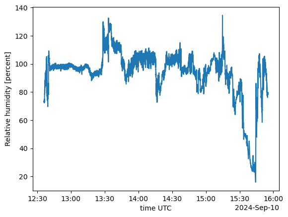
ds_turbu.ALTI_PRESSURE1.plot.scatter()
ds_turbu.ALTI_PRESSURE1.plot()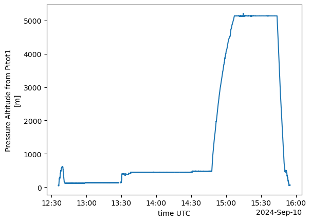
Lecture d’un catalogue STAC pour la decouverte des données
import pystacimport pystac_clientfrom pystac import Catalog, get_stac_version
from pystac.extensions.eo import EOExtension
from pystac.extensions.label import LabelExtensionurl_stac = "https://aeris-recette.ipsl.fr/stac-api/"from pystac_client import Client
headers = []
cat = Client.open(url_stac, headers=headers)cat- type "Catalog"
- id "stac-fastapi"
- stac_version "1.1.0"
- description "stac-fastapi"
links[] 10 items
0
- rel "self"
- href "https://aeris-recette.ipsl.fr/stac-api/"
- type "application/json"
1
- rel "root"
- href "https://aeris-recette.ipsl.fr/stac-api/"
- type "application/json"
- title "stac-fastapi"
2
- rel "data"
- href "https://aeris-recette.ipsl.fr/stac-api/collections"
- type "application/json"
3
- rel "conformance"
- href "https://aeris-recette.ipsl.fr/stac-api/conformance"
- type "application/json"
- title "STAC/WFS3 conformance classes implemented by this server"
4
- rel "search"
- href "https://aeris-recette.ipsl.fr/stac-api/search"
- type "application/geo+json"
- title "STAC search"
- method "GET"
5
- rel "search"
- href "https://aeris-recette.ipsl.fr/stac-api/search"
- type "application/geo+json"
- title "STAC search"
- method "POST"
6
- rel "child"
- href "https://aeris-recette.ipsl.fr/stac-api/collections/MTO-1H"
- type "application/json"
- title "METEO-FRANCE, Hourly data from ground-based stations (RADOME and extended network)"
7
- rel "child"
- href "https://aeris-recette.ipsl.fr/stac-api/collections/MTO-6MIN"
- type "application/json"
- title "METEO-FRANCE, 6 minutes data from ground-based stations (RADOME and extended network)"
8
- rel "service-desc"
- href "https://aeris-recette.ipsl.fr/stac-api/api"
- type "application/vnd.oai.openapi+json;version=3.0"
- title "OpenAPI service description"
9
- rel "service-doc"
- href "https://aeris-recette.ipsl.fr/stac-api/api.html"
- type "text/html"
- title "OpenAPI service documentation"
conformsTo[] 18 items
- 0 "https://api.stacspec.org/v1.0.0/item-search#fields"
- 1 "http://www.opengis.net/spec/ogcapi-features-1/1.0/conf/core"
- 2 "https://api.stacspec.org/v1.0.0/item-search"
- 3 "https://api.stacspec.org/v1.0.0-rc.2/item-search#context"
- 4 "https://api.stacspec.org/v1.0.0/collections"
- 5 "https://api.stacspec.org/v1.0.0-rc.2/item-search#filter"
- 6 "https://api.stacspec.org/v1.0.0/core"
- 7 "http://www.opengis.net/spec/cql2/1.0/conf/cql2-json"
- 8 "http://www.opengis.net/spec/cql2/1.0/conf/cql2-text"
- 9 "https://api.stacspec.org/v1.0.0-rc.3/ogcapi-features/extensions/transaction"
- 10 "https://api.stacspec.org/v1.0.0/item-search#sort"
- 11 "http://www.opengis.net/spec/ogcapi-features-1/1.0/conf/geojson"
- 12 "https://api.stacspec.org/v1.0.0/ogcapi-features"
- 13 "http://www.opengis.net/spec/ogcapi-features-1/1.0/conf/oas30"
- 14 "http://www.opengis.net/spec/ogcapi-features-3/1.0/conf/features-filter"
- 15 "http://www.opengis.net/spec/ogcapi-features-3/1.0/conf/filter"
- 16 "https://api.stacspec.org/v1.0.0/item-search#query"
- 17 "http://www.opengis.net/spec/cql2/1.0/conf/basic-cql2"
- title "stac-fastapi"
Exemple de requête STAC (données horaires, lannemezan) :
curl -X ‘POST’ ‘https://aeris-recette.ipsl.fr/stac-api/search’ -H ‘accept: application/geo+json’ -H ‘Content-Type: application/json’ -d ‘{“collections”: [ “MTO-1H” ], “filter”: { “or”: [ {“eq”:[{“property”:“platform”},“LANNEMEZAN”]} ] }}’
search = cat.search(
    max_items=5,
    limit=5,
    collections="MTO-1H"
)search.get_all_items_as_dict()/opt/conda/envs/tmp/lib/python3.12/site-packages/pystac_client/item_search.py:911: FutureWarning: get_all_items_as_dict() is deprecated, use item_collection_as_dict() instead.
warnings.warn({'type': 'FeatureCollection',
'features': [{'id': '98833002-1H',
'bbox': [165.767333, -21.4555, 165.767333, -21.4555],
'type': 'Feature',
'links': [{'rel': 'collection',
'type': 'application/json',
'href': 'https://aeris-recette.ipsl.fr/stac-api/collections/MTO-1H'},
{'rel': 'parent',
'type': 'application/json',
'href': 'https://aeris-recette.ipsl.fr/stac-api/collections/MTO-1H'},
{'rel': 'root',
'type': 'application/json',
'href': 'https://aeris-recette.ipsl.fr/stac-api/'},
{'rel': 'self',
'type': 'application/geo+json',
'href': 'https://aeris-recette.ipsl.fr/stac-api/collections/MTO-1H/items/98833002-1H'}],
'assets': {'ncss': {'href': 'https://aeris-recette.ipsl.fr/thredds/ncss/point/MTO-1H/MEA-1H.ncml/dataset.html',
'type': 'text/html',
'roles': ['service'],
'title': 'NetCDF Subset Service'},
'98833002-1H.ncml': {'href': 'https://aeris-recette.ipsl.fr/stac/NCML//MTO-1H/MEA-1H.ncml',
'type': 'application/xml',
'roles': ['data'],
'title': 'NCML aggregation'},
'98833002_MEA_MTO_1H_2008.nc': {'href': 'https://thredds-su.ipsl.fr/thredds/fileServer/aeris_thredds/actrisfr_data/665029c8-82b8-4754-9ff4-d558e640b0ba/2008/98833002_MEA_MTO_1H_2008.nc',
'type': 'application/netcdf',
'roles': ['data'],
'title': '2008'},
'98833002_MEA_MTO_1H_2009.nc': {'href': 'https://thredds-su.ipsl.fr/thredds/fileServer/aeris_thredds/actrisfr_data/665029c8-82b8-4754-9ff4-d558e640b0ba/2009/98833002_MEA_MTO_1H_2009.nc',
'type': 'application/netcdf',
'roles': ['data'],
'title': '2009'},
'98833002_MEA_MTO_1H_2010.nc': {'href': 'https://thredds-su.ipsl.fr/thredds/fileServer/aeris_thredds/actrisfr_data/665029c8-82b8-4754-9ff4-d558e640b0ba/2010/98833002_MEA_MTO_1H_2010.nc',
'type': 'application/netcdf',
'roles': ['data'],
'title': '2010'},
'98833002_MEA_MTO_1H_2011.nc': {'href': 'https://thredds-su.ipsl.fr/thredds/fileServer/aeris_thredds/actrisfr_data/665029c8-82b8-4754-9ff4-d558e640b0ba/2011/98833002_MEA_MTO_1H_2011.nc',
'type': 'application/netcdf',
'roles': ['data'],
'title': '2011'},
'98833002_MEA_MTO_1H_2012.nc': {'href': 'https://thredds-su.ipsl.fr/thredds/fileServer/aeris_thredds/actrisfr_data/665029c8-82b8-4754-9ff4-d558e640b0ba/2012/98833002_MEA_MTO_1H_2012.nc',
'type': 'application/netcdf',
'roles': ['data'],
'title': '2012'},
'98833002_MEA_MTO_1H_2013.nc': {'href': 'https://thredds-su.ipsl.fr/thredds/fileServer/aeris_thredds/actrisfr_data/665029c8-82b8-4754-9ff4-d558e640b0ba/2013/98833002_MEA_MTO_1H_2013.nc',
'type': 'application/netcdf',
'roles': ['data'],
'title': '2013'},
'98833002_MEA_MTO_1H_2014.nc': {'href': 'https://thredds-su.ipsl.fr/thredds/fileServer/aeris_thredds/actrisfr_data/665029c8-82b8-4754-9ff4-d558e640b0ba/2014/98833002_MEA_MTO_1H_2014.nc',
'type': 'application/netcdf',
'roles': ['data'],
'title': '2014'},
'98833002_MEA_MTO_1H_2015.nc': {'href': 'https://thredds-su.ipsl.fr/thredds/fileServer/aeris_thredds/actrisfr_data/665029c8-82b8-4754-9ff4-d558e640b0ba/2015/98833002_MEA_MTO_1H_2015.nc',
'type': 'application/netcdf',
'roles': ['data'],
'title': '2015'},
'98833002_MEA_MTO_1H_2016.nc': {'href': 'https://thredds-su.ipsl.fr/thredds/fileServer/aeris_thredds/actrisfr_data/665029c8-82b8-4754-9ff4-d558e640b0ba/2016/98833002_MEA_MTO_1H_2016.nc',
'type': 'application/netcdf',
'roles': ['data'],
'title': '2016'},
'98833002_MEA_MTO_1H_2017.nc': {'href': 'https://thredds-su.ipsl.fr/thredds/fileServer/aeris_thredds/actrisfr_data/665029c8-82b8-4754-9ff4-d558e640b0ba/2017/98833002_MEA_MTO_1H_2017.nc',
'type': 'application/netcdf',
'roles': ['data'],
'title': '2017'},
'98833002_MEA_MTO_1H_2018.nc': {'href': 'https://thredds-su.ipsl.fr/thredds/fileServer/aeris_thredds/actrisfr_data/665029c8-82b8-4754-9ff4-d558e640b0ba/2018/98833002_MEA_MTO_1H_2018.nc',
'type': 'application/netcdf',
'roles': ['data'],
'title': '2018'},
'98833002_MEA_MTO_1H_2019.nc': {'href': 'https://thredds-su.ipsl.fr/thredds/fileServer/aeris_thredds/actrisfr_data/665029c8-82b8-4754-9ff4-d558e640b0ba/2019/98833002_MEA_MTO_1H_2019.nc',
'type': 'application/netcdf',
'roles': ['data'],
'title': '2019'},
'98833002_MEA_MTO_1H_2020.nc': {'href': 'https://thredds-su.ipsl.fr/thredds/fileServer/aeris_thredds/actrisfr_data/665029c8-82b8-4754-9ff4-d558e640b0ba/2020/98833002_MEA_MTO_1H_2020.nc',
'type': 'application/netcdf',
'roles': ['data'],
'title': '2020'},
'98833002_MEA_MTO_1H_2021.nc': {'href': 'https://thredds-su.ipsl.fr/thredds/fileServer/aeris_thredds/actrisfr_data/665029c8-82b8-4754-9ff4-d558e640b0ba/2021/98833002_MEA_MTO_1H_2021.nc',
'type': 'application/netcdf',
'roles': ['data'],
'title': '2021'},
'98833002_MEA_MTO_1H_2022.nc': {'href': 'https://thredds-su.ipsl.fr/thredds/fileServer/aeris_thredds/actrisfr_data/665029c8-82b8-4754-9ff4-d558e640b0ba/2022/98833002_MEA_MTO_1H_2022.nc',
'type': 'application/netcdf',
'roles': ['data'],
'title': '2022'},
'98833002_MEA_MTO_1H_2023.nc': {'href': 'https://thredds-su.ipsl.fr/thredds/fileServer/aeris_thredds/actrisfr_data/665029c8-82b8-4754-9ff4-d558e640b0ba/2023/98833002_MEA_MTO_1H_2023.nc',
'type': 'application/netcdf',
'roles': ['data'],
'title': '2023'}},
'geometry': {'type': 'Point', 'coordinates': [165.767333, -21.4555, 571]},
'collection': 'MTO-1H',
'properties': {'title': 'Data from the MEA weather station - 1H',
'network': 'ETENDU',
'platform': 'MEA',
'providers': [{'name': 'METEO-FRANCE', 'roles': ['producer']},
{'url': 'https://www.aeris-data.fr',
'name': 'AERIS',
'roles': ['processor', 'host']}],
'stationId': '98833002',
'end_datetime': '2025-01-09T00:00:00Z',
'start_datetime': '2004-01-01T00:00:00Z',
'acknowledgement': 'The authors would like to acknowledge Meteo-France for providing the standard meteorological variables used in this study, and the French national center for Atmospheric data and services AERIS for granting access to the data.'},
'stac_version': '1.0.0',
'stac_extensions': []},
{'id': '98832101-1H',
'bbox': [166.9675, -22.269167, 166.9675, -22.269167],
'type': 'Feature',
'links': [{'rel': 'collection',
'type': 'application/json',
'href': 'https://aeris-recette.ipsl.fr/stac-api/collections/MTO-1H'},
{'rel': 'parent',
'type': 'application/json',
'href': 'https://aeris-recette.ipsl.fr/stac-api/collections/MTO-1H'},
{'rel': 'root',
'type': 'application/json',
'href': 'https://aeris-recette.ipsl.fr/stac-api/'},
{'rel': 'self',
'type': 'application/geo+json',
'href': 'https://aeris-recette.ipsl.fr/stac-api/collections/MTO-1H/items/98832101-1H'}],
'assets': {'ncss': {'href': 'https://aeris-recette.ipsl.fr/thredds/ncss/point/MTO-1H/GORO_ANCIENNE_PEPINIERE-1H.ncml/dataset.html',
'type': 'text/html',
'roles': ['service'],
'title': 'NetCDF Subset Service'},
'98832101-1H.ncml': {'href': 'https://aeris-recette.ipsl.fr/stac/NCML//MTO-1H/GORO_ANCIENNE_PEPINIERE-1H.ncml',
'type': 'application/xml',
'roles': ['data'],
'title': 'NCML aggregation'},
'98832101_GORO_ANCIENNE_PEPINIERE_MTO_1H_2010.nc': {'href': 'https://thredds-su.ipsl.fr/thredds/fileServer/aeris_thredds/actrisfr_data/665029c8-82b8-4754-9ff4-d558e640b0ba/2010/98832101_GORO_ANCIENNE_PEPINIERE_MTO_1H_2010.nc',
'type': 'application/netcdf',
'roles': ['data'],
'title': '2010'},
'98832101_GORO_ANCIENNE_PEPINIERE_MTO_1H_2011.nc': {'href': 'https://thredds-su.ipsl.fr/thredds/fileServer/aeris_thredds/actrisfr_data/665029c8-82b8-4754-9ff4-d558e640b0ba/2011/98832101_GORO_ANCIENNE_PEPINIERE_MTO_1H_2011.nc',
'type': 'application/netcdf',
'roles': ['data'],
'title': '2011'},
'98832101_GORO_ANCIENNE_PEPINIERE_MTO_1H_2012.nc': {'href': 'https://thredds-su.ipsl.fr/thredds/fileServer/aeris_thredds/actrisfr_data/665029c8-82b8-4754-9ff4-d558e640b0ba/2012/98832101_GORO_ANCIENNE_PEPINIERE_MTO_1H_2012.nc',
'type': 'application/netcdf',
'roles': ['data'],
'title': '2012'},
'98832101_GORO_ANCIENNE_PEPINIERE_MTO_1H_2013.nc': {'href': 'https://thredds-su.ipsl.fr/thredds/fileServer/aeris_thredds/actrisfr_data/665029c8-82b8-4754-9ff4-d558e640b0ba/2013/98832101_GORO_ANCIENNE_PEPINIERE_MTO_1H_2013.nc',
'type': 'application/netcdf',
'roles': ['data'],
'title': '2013'},
'98832101_GORO_ANCIENNE_PEPINIERE_MTO_1H_2014.nc': {'href': 'https://thredds-su.ipsl.fr/thredds/fileServer/aeris_thredds/actrisfr_data/665029c8-82b8-4754-9ff4-d558e640b0ba/2014/98832101_GORO_ANCIENNE_PEPINIERE_MTO_1H_2014.nc',
'type': 'application/netcdf',
'roles': ['data'],
'title': '2014'},
'98832101_GORO_ANCIENNE_PEPINIERE_MTO_1H_2015.nc': {'href': 'https://thredds-su.ipsl.fr/thredds/fileServer/aeris_thredds/actrisfr_data/665029c8-82b8-4754-9ff4-d558e640b0ba/2015/98832101_GORO_ANCIENNE_PEPINIERE_MTO_1H_2015.nc',
'type': 'application/netcdf',
'roles': ['data'],
'title': '2015'},
'98832101_GORO_ANCIENNE_PEPINIERE_MTO_1H_2016.nc': {'href': 'https://thredds-su.ipsl.fr/thredds/fileServer/aeris_thredds/actrisfr_data/665029c8-82b8-4754-9ff4-d558e640b0ba/2016/98832101_GORO_ANCIENNE_PEPINIERE_MTO_1H_2016.nc',
'type': 'application/netcdf',
'roles': ['data'],
'title': '2016'},
'98832101_GORO_ANCIENNE_PEPINIERE_MTO_1H_2017.nc': {'href': 'https://thredds-su.ipsl.fr/thredds/fileServer/aeris_thredds/actrisfr_data/665029c8-82b8-4754-9ff4-d558e640b0ba/2017/98832101_GORO_ANCIENNE_PEPINIERE_MTO_1H_2017.nc',
'type': 'application/netcdf',
'roles': ['data'],
'title': '2017'},
'98832101_GORO_ANCIENNE_PEPINIERE_MTO_1H_2018.nc': {'href': 'https://thredds-su.ipsl.fr/thredds/fileServer/aeris_thredds/actrisfr_data/665029c8-82b8-4754-9ff4-d558e640b0ba/2018/98832101_GORO_ANCIENNE_PEPINIERE_MTO_1H_2018.nc',
'type': 'application/netcdf',
'roles': ['data'],
'title': '2018'},
'98832101_GORO_ANCIENNE_PEPINIERE_MTO_1H_2019.nc': {'href': 'https://thredds-su.ipsl.fr/thredds/fileServer/aeris_thredds/actrisfr_data/665029c8-82b8-4754-9ff4-d558e640b0ba/2019/98832101_GORO_ANCIENNE_PEPINIERE_MTO_1H_2019.nc',
'type': 'application/netcdf',
'roles': ['data'],
'title': '2019'},
'98832101_GORO_ANCIENNE_PEPINIERE_MTO_1H_2020.nc': {'href': 'https://thredds-su.ipsl.fr/thredds/fileServer/aeris_thredds/actrisfr_data/665029c8-82b8-4754-9ff4-d558e640b0ba/2020/98832101_GORO_ANCIENNE_PEPINIERE_MTO_1H_2020.nc',
'type': 'application/netcdf',
'roles': ['data'],
'title': '2020'},
'98832101_GORO_ANCIENNE_PEPINIERE_MTO_1H_2021.nc': {'href': 'https://thredds-su.ipsl.fr/thredds/fileServer/aeris_thredds/actrisfr_data/665029c8-82b8-4754-9ff4-d558e640b0ba/2021/98832101_GORO_ANCIENNE_PEPINIERE_MTO_1H_2021.nc',
'type': 'application/netcdf',
'roles': ['data'],
'title': '2021'},
'98832101_GORO_ANCIENNE_PEPINIERE_MTO_1H_2022.nc': {'href': 'https://thredds-su.ipsl.fr/thredds/fileServer/aeris_thredds/actrisfr_data/665029c8-82b8-4754-9ff4-d558e640b0ba/2022/98832101_GORO_ANCIENNE_PEPINIERE_MTO_1H_2022.nc',
'type': 'application/netcdf',
'roles': ['data'],
'title': '2022'},
'98832101_GORO_ANCIENNE_PEPINIERE_MTO_1H_2023.nc': {'href': 'https://thredds-su.ipsl.fr/thredds/fileServer/aeris_thredds/actrisfr_data/665029c8-82b8-4754-9ff4-d558e640b0ba/2023/98832101_GORO_ANCIENNE_PEPINIERE_MTO_1H_2023.nc',
'type': 'application/netcdf',
'roles': ['data'],
'title': '2023'}},
'geometry': {'type': 'Point', 'coordinates': [166.9675, -22.269167, 298]},
'collection': 'MTO-1H',
'properties': {'title': 'Data from the GORO_ANCIENNE_PEPINIERE weather station - 1H',
'network': 'ETENDU',
'platform': 'GORO_ANCIENNE_PEPINIERE',
'providers': [{'name': 'METEO-FRANCE', 'roles': ['producer']},
{'url': 'https://www.aeris-data.fr',
'name': 'AERIS',
'roles': ['processor', 'host']}],
'stationId': '98832101',
'end_datetime': '2025-01-09T00:00:00Z',
'start_datetime': '2004-01-01T00:00:00Z',
'acknowledgement': 'The authors would like to acknowledge Meteo-France for providing the standard meteorological variables used in this study, and the French national center for Atmospheric data and services AERIS for granting access to the data.'},
'stac_version': '1.0.0',
'stac_extensions': []},
{'id': '98832005-1H',
'bbox': [166.6805, -21.984, 166.6805, -21.984],
'type': 'Feature',
'links': [{'rel': 'collection',
'type': 'application/json',
'href': 'https://aeris-recette.ipsl.fr/stac-api/collections/MTO-1H'},
{'rel': 'parent',
'type': 'application/json',
'href': 'https://aeris-recette.ipsl.fr/stac-api/collections/MTO-1H'},
{'rel': 'root',
'type': 'application/json',
'href': 'https://aeris-recette.ipsl.fr/stac-api/'},
{'rel': 'self',
'type': 'application/geo+json',
'href': 'https://aeris-recette.ipsl.fr/stac-api/collections/MTO-1H/items/98832005-1H'}],
'assets': {'ncss': {'href': 'https://aeris-recette.ipsl.fr/thredds/ncss/point/MTO-1H/OUINNE-1H.ncml/dataset.html',
'type': 'text/html',
'roles': ['service'],
'title': 'NetCDF Subset Service'},
'98832005-1H.ncml': {'href': 'https://aeris-recette.ipsl.fr/stac/NCML//MTO-1H/OUINNE-1H.ncml',
'type': 'application/xml',
'roles': ['data'],
'title': 'NCML aggregation'},
'98832005_OUINNE_MTO_1H_2021.nc': {'href': 'https://thredds-su.ipsl.fr/thredds/fileServer/aeris_thredds/actrisfr_data/665029c8-82b8-4754-9ff4-d558e640b0ba/2021/98832005_OUINNE_MTO_1H_2021.nc',
'type': 'application/netcdf',
'roles': ['data'],
'title': '2021'},
'98832005_OUINNE_MTO_1H_2022.nc': {'href': 'https://thredds-su.ipsl.fr/thredds/fileServer/aeris_thredds/actrisfr_data/665029c8-82b8-4754-9ff4-d558e640b0ba/2022/98832005_OUINNE_MTO_1H_2022.nc',
'type': 'application/netcdf',
'roles': ['data'],
'title': '2022'},
'98832005_OUINNE_MTO_1H_2023.nc': {'href': 'https://thredds-su.ipsl.fr/thredds/fileServer/aeris_thredds/actrisfr_data/665029c8-82b8-4754-9ff4-d558e640b0ba/2023/98832005_OUINNE_MTO_1H_2023.nc',
'type': 'application/netcdf',
'roles': ['data'],
'title': '2023'}},
'geometry': {'type': 'Point', 'coordinates': [166.6805, -21.984, 54]},
'collection': 'MTO-1H',
'properties': {'title': 'Data from the OUINNE weather station - 1H',
'network': 'ETENDU',
'platform': 'OUINNE',
'providers': [{'name': 'METEO-FRANCE', 'roles': ['producer']},
{'url': 'https://www.aeris-data.fr',
'name': 'AERIS',
'roles': ['processor', 'host']}],
'stationId': '98832005',
'end_datetime': '2025-01-09T00:00:00Z',
'start_datetime': '2004-01-01T00:00:00Z',
'acknowledgement': 'The authors would like to acknowledge Meteo-France for providing the standard meteorological variables used in this study, and the French national center for Atmospheric data and services AERIS for granting access to the data.'},
'stac_version': '1.0.0',
'stac_extensions': []},
{'id': '98831001-1H',
'bbox': [164.6875, -20.950167, 164.6875, -20.950167],
'type': 'Feature',
'links': [{'rel': 'collection',
'type': 'application/json',
'href': 'https://aeris-recette.ipsl.fr/stac-api/collections/MTO-1H'},
{'rel': 'parent',
'type': 'application/json',
'href': 'https://aeris-recette.ipsl.fr/stac-api/collections/MTO-1H'},
{'rel': 'root',
'type': 'application/json',
'href': 'https://aeris-recette.ipsl.fr/stac-api/'},
{'rel': 'self',
'type': 'application/geo+json',
'href': 'https://aeris-recette.ipsl.fr/stac-api/collections/MTO-1H/items/98831001-1H'}],
'assets': {'ncss': {'href': 'https://aeris-recette.ipsl.fr/thredds/ncss/point/MTO-1H/VOH-1H.ncml/dataset.html',
'type': 'text/html',
'roles': ['service'],
'title': 'NetCDF Subset Service'},
'98831001-1H.ncml': {'href': 'https://aeris-recette.ipsl.fr/stac/NCML//MTO-1H/VOH-1H.ncml',
'type': 'application/xml',
'roles': ['data'],
'title': 'NCML aggregation'},
'98831001_VOH_MTO_1H_2019.nc': {'href': 'https://thredds-su.ipsl.fr/thredds/fileServer/aeris_thredds/actrisfr_data/665029c8-82b8-4754-9ff4-d558e640b0ba/2019/98831001_VOH_MTO_1H_2019.nc',
'type': 'application/netcdf',
'roles': ['data'],
'title': '2019'},
'98831001_VOH_MTO_1H_2020.nc': {'href': 'https://thredds-su.ipsl.fr/thredds/fileServer/aeris_thredds/actrisfr_data/665029c8-82b8-4754-9ff4-d558e640b0ba/2020/98831001_VOH_MTO_1H_2020.nc',
'type': 'application/netcdf',
'roles': ['data'],
'title': '2020'},
'98831001_VOH_MTO_1H_2021.nc': {'href': 'https://thredds-su.ipsl.fr/thredds/fileServer/aeris_thredds/actrisfr_data/665029c8-82b8-4754-9ff4-d558e640b0ba/2021/98831001_VOH_MTO_1H_2021.nc',
'type': 'application/netcdf',
'roles': ['data'],
'title': '2021'},
'98831001_VOH_MTO_1H_2022.nc': {'href': 'https://thredds-su.ipsl.fr/thredds/fileServer/aeris_thredds/actrisfr_data/665029c8-82b8-4754-9ff4-d558e640b0ba/2022/98831001_VOH_MTO_1H_2022.nc',
'type': 'application/netcdf',
'roles': ['data'],
'title': '2022'},
'98831001_VOH_MTO_1H_2023.nc': {'href': 'https://thredds-su.ipsl.fr/thredds/fileServer/aeris_thredds/actrisfr_data/665029c8-82b8-4754-9ff4-d558e640b0ba/2023/98831001_VOH_MTO_1H_2023.nc',
'type': 'application/netcdf',
'roles': ['data'],
'title': '2023'}},
'geometry': {'type': 'Point', 'coordinates': [164.6875, -20.950167, 6]},
'collection': 'MTO-1H',
'properties': {'title': 'Data from the VOH weather station - 1H',
'network': 'ETENDU',
'platform': 'VOH',
'providers': [{'name': 'METEO-FRANCE', 'roles': ['producer']},
{'url': 'https://www.aeris-data.fr',
'name': 'AERIS',
'roles': ['processor', 'host']}],
'stationId': '98831001',
'end_datetime': '2025-01-09T00:00:00Z',
'start_datetime': '2004-01-01T00:00:00Z',
'acknowledgement': 'The authors would like to acknowledge Meteo-France for providing the standard meteorological variables used in this study, and the French national center for Atmospheric data and services AERIS for granting access to the data.'},
'stac_version': '1.0.0',
'stac_extensions': []},
{'id': '98830003-1H',
'bbox': [165.217833, -20.899167, 165.217833, -20.899167],
'type': 'Feature',
'links': [{'rel': 'collection',
'type': 'application/json',
'href': 'https://aeris-recette.ipsl.fr/stac-api/collections/MTO-1H'},
{'rel': 'parent',
'type': 'application/json',
'href': 'https://aeris-recette.ipsl.fr/stac-api/collections/MTO-1H'},
{'rel': 'root',
'type': 'application/json',
'href': 'https://aeris-recette.ipsl.fr/stac-api/'},
{'rel': 'self',
'type': 'application/geo+json',
'href': 'https://aeris-recette.ipsl.fr/stac-api/collections/MTO-1H/items/98830003-1H'}],
'assets': {'ncss': {'href': 'https://aeris-recette.ipsl.fr/thredds/ncss/point/MTO-1H/TIWAKA-1H.ncml/dataset.html',
'type': 'text/html',
'roles': ['service'],
'title': 'NetCDF Subset Service'},
'98830003-1H.ncml': {'href': 'https://aeris-recette.ipsl.fr/stac/NCML//MTO-1H/TIWAKA-1H.ncml',
'type': 'application/xml',
'roles': ['data'],
'title': 'NCML aggregation'},
'98830003_TIWAKA_MTO_1H_2020.nc': {'href': 'https://thredds-su.ipsl.fr/thredds/fileServer/aeris_thredds/actrisfr_data/665029c8-82b8-4754-9ff4-d558e640b0ba/2020/98830003_TIWAKA_MTO_1H_2020.nc',
'type': 'application/netcdf',
'roles': ['data'],
'title': '2020'},
'98830003_TIWAKA_MTO_1H_2021.nc': {'href': 'https://thredds-su.ipsl.fr/thredds/fileServer/aeris_thredds/actrisfr_data/665029c8-82b8-4754-9ff4-d558e640b0ba/2021/98830003_TIWAKA_MTO_1H_2021.nc',
'type': 'application/netcdf',
'roles': ['data'],
'title': '2021'},
'98830003_TIWAKA_MTO_1H_2022.nc': {'href': 'https://thredds-su.ipsl.fr/thredds/fileServer/aeris_thredds/actrisfr_data/665029c8-82b8-4754-9ff4-d558e640b0ba/2022/98830003_TIWAKA_MTO_1H_2022.nc',
'type': 'application/netcdf',
'roles': ['data'],
'title': '2022'},
'98830003_TIWAKA_MTO_1H_2023.nc': {'href': 'https://thredds-su.ipsl.fr/thredds/fileServer/aeris_thredds/actrisfr_data/665029c8-82b8-4754-9ff4-d558e640b0ba/2023/98830003_TIWAKA_MTO_1H_2023.nc',
'type': 'application/netcdf',
'roles': ['data'],
'title': '2023'}},
'geometry': {'type': 'Point', 'coordinates': [165.217833, -20.899167, 14]},
'collection': 'MTO-1H',
'properties': {'title': 'Data from the TIWAKA weather station - 1H',
'network': 'ETENDU',
'platform': 'TIWAKA',
'providers': [{'name': 'METEO-FRANCE', 'roles': ['producer']},
{'url': 'https://www.aeris-data.fr',
'name': 'AERIS',
'roles': ['processor', 'host']}],
'stationId': '98830003',
'end_datetime': '2025-01-09T00:00:00Z',
'start_datetime': '2004-01-01T00:00:00Z',
'acknowledgement': 'The authors would like to acknowledge Meteo-France for providing the standard meteorological variables used in this study, and the French national center for Atmospheric data and services AERIS for granting access to the data.'},
'stac_version': '1.0.0',
'stac_extensions': []}]}ds_cat_aeris= xr.open_dataset('https://thredds-su.ipsl.fr/thredds/dodsC/aeris_thredds/actrisfr_data/665029c8-82b8-4754-9ff4-d558e640b0ba/2010/98832101_GORO_ANCIENNE_PEPINIERE_MTO_1H_2010.nc')
ds_cat_aeris<xarray.Dataset> Size: 23kB
Dimensions: (time: 202)
Coordinates:
* time (time) datetime64[ns] 2kB 2010-12-23T14:00:00 ... 2010-1...
station_name |S64 64B ...
lon float32 4B ...
lat float32 4B ...
alt float32 4B ...
Data variables: (12/26)
td (time) float32 808B ...
ta (time) float32 808B ...
ta_max (time) float32 808B ...
ta_min (time) float32 808B ...
rh (time) float32 808B ...
rh_max (time) float32 808B ...
... ...
snow_height (time) float32 808B ...
nebulosity (time) float32 808B ...
insolh_duration (time) float32 808B ...
glo (time) float32 808B ...
pres (time) float32 808B ...
pres_sl (time) float32 808B ...
Attributes: (12/51)
title: Ground meteorological data from GORO_ANC...
summary: This dataset contains meteorological dat...
keywords: GCMD:EARTH SCIENCE,GCMD:ATMOSPHERE,GCMD:...
institution: Meteo-France
source: Meteo-France operational weather station...
comment: Source data retrieved from the Meteo-Fra...
... ...
instrument_vocabulary: GCMD:GCMD Keywords
cdm_data_type: station
DODS.strlen: 23
DODS.dimName: strlen
DODS_EXTRA.Unlimited_Dimension: time
EXTRA_DIMENSION.nv: 2cat.get_links('child')[<Link rel=child target=https://aeris-recette.ipsl.fr/stac-api/collections/MTO-1H>,
<Link rel=child target=https://aeris-recette.ipsl.fr/stac-api/collections/MTO-6MIN>]from typing import Optional, List, Dict, Any
def search_items(
self,
collections: Optional[List[str]] = None,
bbox: Optional[List[float]] = None,
datetime_range: Optional[str] = None,
limit: Optional[int] = None,
max_items: Optional[int] = None,
query: Optional[Dict[str, Any]] = None
) -> List[Dict[str, Any]]:
"""
Recherche des items dans le catalogue STAC
Args:
collections: Liste des IDs de collections (ex: ['MTO-1H', 'MTO-6MIN'])
bbox: Bounding box [min_lon, min_lat, max_lon, max_lat]
datetime_range: Intervalle temporel (ex: '2024-01-01T00:00:00Z/2024-01-31T23:59:59Z')
limit: Nombre d'items par page
max_items: Nombre maximum d'items à récupérer (None = tous)
query: Filtres additionnels (CQL2)
Returns:
Liste des items trouvés (sous forme de dictionnaires)
"""
search_params = {}
if collections:
search_params["collections"] = collections
if bbox:
search_params["bbox"] = bbox
if datetime_range:
search_params["datetime"] = datetime_range
if limit:
search_params["limit"] = limit
if max_items:
search_params["max_items"] = max_items
if query:
search_params["query"] = query
print(f"Paramètres de recherche: {search_params}")
# Effectuer la recherche
search = self.client.search(**search_params)
# Récupérer tous les items
items = []
page = 1
try:
item_collection = search.item_collection()
total = len(item_collection)
print(f"Récupération de {total} items...")
for item in item_collection:
items.append(item.to_dict())
except Exception as e:
# Fallback: itérer manuellement
print(f"Utilisation de l'itération manuelle...")
for i, item in enumerate(search.items(), 1):
items.append(item.to_dict())
if i % 100 == 0:
print(f" -> {i} items récupérés...")
if max_items and i >= max_items:
break
print(f"Total: {len(items)} items trouvés")
return itemscat- type "Catalog"
- id "stac-fastapi"
- stac_version "1.1.0"
- description "stac-fastapi"
links[] 10 items
0
- rel "self"
- href "https://aeris-recette.ipsl.fr/stac-api/"
- type "application/json"
1
- rel "root"
- href "https://aeris-recette.ipsl.fr/stac-api/"
- type "application/json"
- title "stac-fastapi"
2
- rel "data"
- href "https://aeris-recette.ipsl.fr/stac-api/collections"
- type "application/json"
3
- rel "conformance"
- href "https://aeris-recette.ipsl.fr/stac-api/conformance"
- type "application/json"
- title "STAC/WFS3 conformance classes implemented by this server"
4
- rel "search"
- href "https://aeris-recette.ipsl.fr/stac-api/search"
- type "application/geo+json"
- title "STAC search"
- method "GET"
5
- rel "search"
- href "https://aeris-recette.ipsl.fr/stac-api/search"
- type "application/geo+json"
- title "STAC search"
- method "POST"
6
- rel "child"
- href "https://aeris-recette.ipsl.fr/stac-api/collections/MTO-1H"
- type "application/json"
- title "METEO-FRANCE, Hourly data from ground-based stations (RADOME and extended network)"
7
- rel "child"
- href "https://aeris-recette.ipsl.fr/stac-api/collections/MTO-6MIN"
- type "application/json"
- title "METEO-FRANCE, 6 minutes data from ground-based stations (RADOME and extended network)"
8
- rel "service-desc"
- href "https://aeris-recette.ipsl.fr/stac-api/api"
- type "application/vnd.oai.openapi+json;version=3.0"
- title "OpenAPI service description"
9
- rel "service-doc"
- href "https://aeris-recette.ipsl.fr/stac-api/api.html"
- type "text/html"
- title "OpenAPI service documentation"
conformsTo[] 18 items
- 0 "https://api.stacspec.org/v1.0.0/item-search#fields"
- 1 "http://www.opengis.net/spec/ogcapi-features-1/1.0/conf/core"
- 2 "https://api.stacspec.org/v1.0.0/item-search"
- 3 "https://api.stacspec.org/v1.0.0-rc.2/item-search#context"
- 4 "https://api.stacspec.org/v1.0.0/collections"
- 5 "https://api.stacspec.org/v1.0.0-rc.2/item-search#filter"
- 6 "https://api.stacspec.org/v1.0.0/core"
- 7 "http://www.opengis.net/spec/cql2/1.0/conf/cql2-json"
- 8 "http://www.opengis.net/spec/cql2/1.0/conf/cql2-text"
- 9 "https://api.stacspec.org/v1.0.0-rc.3/ogcapi-features/extensions/transaction"
- 10 "https://api.stacspec.org/v1.0.0/item-search#sort"
- 11 "http://www.opengis.net/spec/ogcapi-features-1/1.0/conf/geojson"
- 12 "https://api.stacspec.org/v1.0.0/ogcapi-features"
- 13 "http://www.opengis.net/spec/ogcapi-features-1/1.0/conf/oas30"
- 14 "http://www.opengis.net/spec/ogcapi-features-3/1.0/conf/features-filter"
- 15 "http://www.opengis.net/spec/ogcapi-features-3/1.0/conf/filter"
- 16 "https://api.stacspec.org/v1.0.0/item-search#query"
- 17 "http://www.opengis.net/spec/cql2/1.0/conf/basic-cql2"
- title "stac-fastapi"
import requestsr = requests.get(url_stac+'/collections')
print(r)<Response [200]>r.json(){'collections': [{'id': 'MTO-1H',
'type': 'Collection',
'links': [{'rel': 'items',
'type': 'application/geo+json',
'href': 'https://aeris-recette.ipsl.fr/stac-api/collections/MTO-1H/items'},
{'rel': 'parent',
'type': 'application/json',
'href': 'https://aeris-recette.ipsl.fr/stac-api/'},
{'rel': 'root',
'type': 'application/json',
'href': 'https://aeris-recette.ipsl.fr/stac-api/'},
{'rel': 'self',
'type': 'application/json',
'href': 'https://aeris-recette.ipsl.fr/stac-api/collections/MTO-1H'},
{'rel': 'license',
'href': 'https://www.etalab.gouv.fr/wp-content/uploads/2014/05/Licence_Ouverte.pdf',
'type': 'application/pdf',
'title': "Licence Ouverte d'Etalab"}],
'title': 'METEO-FRANCE, Hourly data from ground-based stations (RADOME and extended network)',
'assets': {'stations': {'href': 'https://aeris-recette.ipsl.fr/stac/assets/listeStations_Metro-OM_PackRadome.csv',
'type': 'text/csv',
'roles': ['metadata'],
'title': 'Stations list'},
'catalogue': {'href': 'https://www.aeris-data.fr/catalogue/?uuid=665029c8-82b8-4754-9ff4-d558e640b0ba',
'type': 'text/html',
'roles': ['metadata'],
'title': 'AERIS catalogue'},
'thumbnail': {'href': 'https://aeris-recette.ipsl.fr/stac/assets/anemometer-3977718_1280.jpg',
'type': 'image/jpeg',
'roles': ['thumbnail']},
'json_aeris': {'href': 'https://api.sedoo.fr/aeris-catalogue-prod/metadata/665029c8-82b8-4754-9ff4-d558e640b0ba',
'type': 'application/json',
'roles': ['metadata'],
'title': 'AERIS metadata'},
'stations_geojson': {'href': 'https://aeris-recette.ipsl.fr/stac/MTO-1H/stations.json',
'type': 'application/geo+json',
'roles': ['metadata'],
'title': 'Stations list'}},
'extent': {'spatial': {'bbox': [[-178.121,
-46.4325,
167.884333,
51.055833]]},
'temporal': {'interval': [['2004-01-01T00:00:00Z',
'2025-01-09T00:00:00Z']]}},
'license': 'proprietary',
'keywords': ['Atmospheric pressure',
'Atmospheric temperature',
'Dew point temperature',
'Insolation',
'Precipitation',
'Relative humidity',
'Shortwave flux',
'Soil state',
'Soil temperature',
'Surface snow thickness',
'Total nebulosity',
'Visibility',
'Wind direction',
'Wind speed'],
'providers': [{'name': 'METEO-FRANCE', 'roles': ['producer']},
{'url': 'https://www.aeris-data.fr',
'name': 'AERIS',
'roles': ['processor', 'host']}],
'description': 'Data measured at automatic stations in the French network with hourly time steps. Basic parameters (temperature, humidity, wind direction and force, precipitation) and additional parameters depending on instrumentation (ground temperature, visibility, ground conditions, insolation, global radiation).',
'stac_version': '1.0.0'},
{'id': 'MTO-6MIN',
'type': 'Collection',
'links': [{'rel': 'items',
'type': 'application/geo+json',
'href': 'https://aeris-recette.ipsl.fr/stac-api/collections/MTO-6MIN/items'},
{'rel': 'parent',
'type': 'application/json',
'href': 'https://aeris-recette.ipsl.fr/stac-api/'},
{'rel': 'root',
'type': 'application/json',
'href': 'https://aeris-recette.ipsl.fr/stac-api/'},
{'rel': 'self',
'type': 'application/json',
'href': 'https://aeris-recette.ipsl.fr/stac-api/collections/MTO-6MIN'},
{'rel': 'license',
'href': 'https://www.etalab.gouv.fr/wp-content/uploads/2014/05/Licence_Ouverte.pdf',
'type': 'application/pdf',
'title': "Licence Ouverte d'Etalab"}],
'title': 'METEO-FRANCE, 6 minutes data from ground-based stations (RADOME and extended network)',
'assets': {'stations': {'href': 'https://aeris-recette.ipsl.fr/stac/assets/listeStations_Metro-OM_PackRadome.csv',
'type': 'text/csv',
'roles': ['metadata'],
'title': 'Stations list'},
'catalogue': {'href': 'https://www.aeris-data.fr/catalogue/?uuid=cbe74172-66e4-4e18-b2cc-31ad11ed934d',
'type': 'text/html',
'roles': ['metadata'],
'title': 'AERIS catalogue'},
'thumbnail': {'href': 'https://aeris-recette.ipsl.fr/stac/assets/anemometer-3977718_1280.jpg',
'type': 'image/jpeg',
'roles': ['thumbnail']},
'json_aeris': {'href': 'https://api.sedoo.fr/aeris-catalogue-prod/metadata/cbe74172-66e4-4e18-b2cc-31ad11ed934d',
'type': 'application/json',
'roles': ['metadata'],
'title': 'AERIS metadata'},
'stations_geojson': {'href': 'https://aeris-recette.ipsl.fr/stac/MTO-6MIN/stations.json',
'type': 'application/geo+json',
'roles': ['metadata'],
'title': 'Stations list'}},
'extent': {'spatial': {'bbox': [[-152.8045,
-27.618333,
167.884333,
51.055833]]},
'temporal': {'interval': [['2004-01-01T00:00:00Z',
'2025-01-09T00:00:00Z']]}},
'license': 'proprietary',
'keywords': ['Atmospheric pressure',
'Atmospheric temperature',
'Dew point temperature',
'Insolation',
'Precipitation',
'Relative humidity',
'Shortwave flux',
'Soil state',
'Soil temperature',
'Surface snow thickness',
'Total nebulosity',
'Visibility',
'Wind direction',
'Wind speed'],
'providers': [{'name': 'METEO-FRANCE', 'roles': ['producer']},
{'url': 'https://www.aeris-data.fr',
'name': 'AERIS',
'roles': ['processor', 'host']}],
'description': 'Data measured at automatic stations in the French network with infra timetable steps (6 minutes). Basic parameters (temperature, humidity, wind direction and force, precipitation) and additional parameters depending on instrumentation (ground temperature, visibility, ground conditions, insolation, global radiation).',
'stac_version': '1.0.0'}],
'links': [{'rel': 'root',
'type': 'application/json',
'href': 'https://aeris-recette.ipsl.fr/stac-api/'},
{'rel': 'parent',
'type': 'application/json',
'href': 'https://aeris-recette.ipsl.fr/stac-api/'},
{'rel': 'self',
'type': 'application/json',
'href': 'https://aeris-recette.ipsl.fr/stac-api/collections'}]}url_stac = 'https://ap.icare.univ-lille.fr/colocation/v1/stac'
cat = Client.open(url_stac,)
cat- type "Catalog"
- id "colocation-stac-catalog"
- stac_version "1.1.0"
- description "Colocation Geospatial Data Catalog"
links[] 6 items
0
- rel "self"
- href "https://ap.icare.univ-lille.fr/colocation/v1/stac"
- type "application/json"
1
- rel "root"
- href "https://ap.icare.univ-lille.fr/colocation/v1/stac"
- type "application/json"
- title "Colocation STAC Catalog"
2
- rel "data"
- href "https://ap.icare.univ-lille.fr/colocation/v1/stac/collections"
- type "application/json"
- title "Collections"
3
- rel "conformance"
- href "https://ap.icare.univ-lille.fr/colocation/v1/stac/conformance"
- type "application/json"
- title "Conformance"
4
- rel "service-desc"
- href "https://ap.icare.univ-lille.fr/colocation/openapi.json"
- type "application/json"
- title "OpenAPI service description"
5
- rel "service-doc"
- href "https://ap.icare.univ-lille.fr/colocation/docs"
- type "text/html"
- title "OpenAPI service documentation"
conformsTo[] 5 items
- 0 "https://api.stacspec.org/v1.0.0/core"
- 1 "https://api.stacspec.org/v1.0.0/ogcapi-features"
- 2 "https://api.stacspec.org/v1.0.0/collections"
- 3 "http://www.opengis.net/spec/ogcapi-features-1/1.0/conf/core"
- 4 "http://www.opengis.net/spec/ogcapi-features-1/1.0/conf/geojson"
- title "Colocation STAC Catalog"
r = requests.get(url_stac+'/collections')
print(r)
<Response [200]>stac = Client.open("https://planetarycomputer.microsoft.com/api/stac/v1")
search = stac.search(collections=["sentinel-2-l2a"],max_items=5)search<pystac_client.item_search.ItemSearch at 0x7f63c8f4b6b0>items = list(search.items())items[<Item id=S2C_MSIL2A_20251119T094321_R036_T34UFC_20251119T113511>,
<Item id=S2C_MSIL2A_20251119T094321_R036_T34UFA_20251119T113511>,
<Item id=S2C_MSIL2A_20251119T094321_R036_T34UCU_20251119T113511>,
<Item id=S2A_MSIL2A_20251119T090411_R007_T37VDE_20251119T102519>,
<Item id=S2A_MSIL2A_20251119T090411_R007_T37VDD_20251119T102519>]url_stac="https://s3.waw3-1.cloudferro.com/mdl-metadata/metadata/catalog.stac.json"
stac = Client.open(url_stac)
stac/opt/conda/envs/tmp/lib/python3.12/site-packages/pystac_client/client.py:186: NoConformsTo: Server does not advertise any conformance classes.
warnings.warn(NoConformsTo())- type "Catalog"
- id "MDS"
- stac_version "1.1.0"
- description "Data from the Copernicus Marine Data Store, in Analysis-Ready, Cloud-Optimised (ARCO) format. "
links[] 330 items
0
- rel "self"
- href "https://s3.waw3-1.cloudferro.com/mdl-metadata/metadata/catalog.stac.json"
- type "application/json"
1
- rel "root"
- href "."
- type "application/json"
- title "Copernicus Marine Data Store"
2
- rel "child"
- href "GLOBAL_ANALYSISFORECAST_PHY_001_024/product.stac.json"
- type "application/json"
- title "GLOBAL_ANALYSISFORECAST_PHY_001_024"
3
- rel "child"
- href "NWSHELF_MULTIYEAR_BGC_004_011/product.stac.json"
- type "application/json"
- title "NWSHELF_MULTIYEAR_BGC_004_011"
4
- rel "child"
- href "GLOBAL_MULTIYEAR_PHY_001_030/product.stac.json"
- type "application/json"
- title "GLOBAL_MULTIYEAR_PHY_001_030"
5
- rel "child"
- href "GLOBAL_ANALYSISFORECAST_WAV_001_027/product.stac.json"
- type "application/json"
- title "GLOBAL_ANALYSISFORECAST_WAV_001_027"
6
- rel "child"
- href "SEALEVEL_GLO_PHY_L4_MY_008_047/product.stac.json"
- type "application/json"
- title "SEALEVEL_GLO_PHY_L4_MY_008_047"
7
- rel "child"
- href "GLOBAL_MULTIYEAR_BGC_001_029/product.stac.json"
- type "application/json"
- title "GLOBAL_MULTIYEAR_BGC_001_029"
8
- rel "child"
- href "NWSHELF_MULTIYEAR_PHY_004_009/product.stac.json"
- type "application/json"
- title "NWSHELF_MULTIYEAR_PHY_004_009"
9
- rel "child"
- href "GLOBAL_MULTIYEAR_WAV_001_032/product.stac.json"
- type "application/json"
- title "GLOBAL_MULTIYEAR_WAV_001_032"
10
- rel "child"
- href "MEDSEA_ANALYSISFORECAST_PHY_006_013/product.stac.json"
- type "application/json"
- title "MEDSEA_ANALYSISFORECAST_PHY_006_013"
11
- rel "child"
- href "GLOBAL_MULTIYEAR_BGC_001_033/product.stac.json"
- type "application/json"
- title "GLOBAL_MULTIYEAR_BGC_001_033"
12
- rel "child"
- href "BALTICSEA_ANALYSISFORECAST_BGC_003_007/product.stac.json"
- type "application/json"
- title "BALTICSEA_ANALYSISFORECAST_BGC_003_007"
13
- rel "child"
- href "BALTICSEA_ANALYSISFORECAST_PHY_003_006/product.stac.json"
- type "application/json"
- title "BALTICSEA_ANALYSISFORECAST_PHY_003_006"
14
- rel "child"
- href "BALTICSEA_ANALYSISFORECAST_WAV_003_010/product.stac.json"
- type "application/json"
- title "BALTICSEA_ANALYSISFORECAST_WAV_003_010"
15
- rel "child"
- href "BALTICSEA_MULTIYEAR_BGC_003_012/product.stac.json"
- type "application/json"
- title "BALTICSEA_MULTIYEAR_BGC_003_012"
16
- rel "child"
- href "BALTICSEA_MULTIYEAR_PHY_003_011/product.stac.json"
- type "application/json"
- title "BALTICSEA_MULTIYEAR_PHY_003_011"
17
- rel "child"
- href "BLKSEA_ANALYSISFORECAST_BGC_007_010/product.stac.json"
- type "application/json"
- title "BLKSEA_ANALYSISFORECAST_BGC_007_010"
18
- rel "child"
- href "BLKSEA_ANALYSISFORECAST_PHY_007_001/product.stac.json"
- type "application/json"
- title "BLKSEA_ANALYSISFORECAST_PHY_007_001"
19
- rel "child"
- href "BLKSEA_ANALYSISFORECAST_WAV_007_003/product.stac.json"
- type "application/json"
- title "BLKSEA_ANALYSISFORECAST_WAV_007_003"
20
- rel "child"
- href "BALTIC_OMI_HEALTH_codt_volume/product.stac.json"
- type "application/json"
- title "BALTIC_OMI_HEALTH_codt_volume"
21
- rel "child"
- href "BALTIC_OMI_SI_extent/product.stac.json"
- type "application/json"
- title "BALTIC_OMI_SI_extent"
22
- rel "child"
- href "BALTIC_OMI_SI_volume/product.stac.json"
- type "application/json"
- title "BALTIC_OMI_SI_volume"
23
- rel "child"
- href "BALTIC_OMI_TEMPSAL_Stz_trend/product.stac.json"
- type "application/json"
- title "BALTIC_OMI_TEMPSAL_Stz_trend"
24
- rel "child"
- href "BALTIC_OMI_TEMPSAL_Ttz_trend/product.stac.json"
- type "application/json"
- title "BALTIC_OMI_TEMPSAL_Ttz_trend"
25
- rel "child"
- href "BALTIC_OMI_WMHE_mbi_bottom_salinity_arkona_bornholm/product.stac.json"
- type "application/json"
- title "BALTIC_OMI_WMHE_mbi_bottom_salinity_arkona_bornholm"
26
- rel "child"
- href "BALTIC_OMI_WMHE_mbi_sto2tz_gotland/product.stac.json"
- type "application/json"
- title "BALTIC_OMI_WMHE_mbi_sto2tz_gotland"
27
- rel "child"
- href "BLKSEA_MULTIYEAR_WAV_007_006/product.stac.json"
- type "application/json"
- title "BLKSEA_MULTIYEAR_WAV_007_006"
28
- rel "child"
- href "BLKSEA_MULTIYEAR_PHY_007_004/product.stac.json"
- type "application/json"
- title "BLKSEA_MULTIYEAR_PHY_007_004"
29
- rel "child"
- href "BLKSEA_OMI_HEALTH_oxygen_trend/product.stac.json"
- type "application/json"
- title "BLKSEA_OMI_HEALTH_oxygen_trend"
30
- rel "child"
- href "BLKSEA_OMI_SEASTATE_extreme_var_swh_mean_and_anomaly/product.stac.json"
- type "application/json"
- title "BLKSEA_OMI_SEASTATE_extreme_var_swh_mean_and_anomaly"
31
- rel "child"
- href "BLKSEA_OMI_TEMPSAL_extreme_var_temp_mean_and_anomaly/product.stac.json"
- type "application/json"
- title "BLKSEA_OMI_TEMPSAL_extreme_var_temp_mean_and_anomaly"
32
- rel "child"
- href "BLKSEA_OMI_TEMPSAL_sst_area_averaged_anomalies/product.stac.json"
- type "application/json"
- title "BLKSEA_OMI_TEMPSAL_sst_area_averaged_anomalies"
33
- rel "child"
- href "BLKSEA_OMI_TEMPSAL_sst_trend/product.stac.json"
- type "application/json"
- title "BLKSEA_OMI_TEMPSAL_sst_trend"
34
- rel "child"
- href "MEDSEA_MULTIYEAR_WAV_006_012/product.stac.json"
- type "application/json"
- title "MEDSEA_MULTIYEAR_WAV_006_012"
35
- rel "child"
- href "MEDSEA_OMI_SEASTATE_extreme_var_swh_mean_and_anomaly/product.stac.json"
- type "application/json"
- title "MEDSEA_OMI_SEASTATE_extreme_var_swh_mean_and_anomaly"
36
- rel "child"
- href "MEDSEA_OMI_TEMPSAL_extreme_var_temp_mean_and_anomaly/product.stac.json"
- type "application/json"
- title "MEDSEA_OMI_TEMPSAL_extreme_var_temp_mean_and_anomaly"
37
- rel "child"
- href "MEDSEA_OMI_TEMPSAL_sst_area_averaged_anomalies/product.stac.json"
- type "application/json"
- title "MEDSEA_OMI_TEMPSAL_sst_area_averaged_anomalies"
38
- rel "child"
- href "MEDSEA_OMI_TEMPSAL_sst_trend/product.stac.json"
- type "application/json"
- title "MEDSEA_OMI_TEMPSAL_sst_trend"
39
- rel "child"
- href "GLOBAL_OMI_CLIMVAR_enso_Tzt_anomaly/product.stac.json"
- type "application/json"
- title "GLOBAL_OMI_CLIMVAR_enso_Tzt_anomaly"
40
- rel "child"
- href "GLOBAL_OMI_CLIMVAR_enso_sst_area_averaged_anomalies/product.stac.json"
- type "application/json"
- title "GLOBAL_OMI_CLIMVAR_enso_sst_area_averaged_anomalies"
41
- rel "child"
- href "GLOBAL_OMI_NATLANTIC_amoc_26N_profile/product.stac.json"
- type "application/json"
- title "GLOBAL_OMI_NATLANTIC_amoc_26N_profile"
42
- rel "child"
- href "GLOBAL_OMI_NATLANTIC_amoc_max26N_timeseries/product.stac.json"
- type "application/json"
- title "GLOBAL_OMI_NATLANTIC_amoc_max26N_timeseries"
43
- rel "child"
- href "GLOBAL_OMI_OHC_trend/product.stac.json"
- type "application/json"
- title "GLOBAL_OMI_OHC_trend"
44
- rel "child"
- href "GLOBAL_OMI_SL_thsl_trend/product.stac.json"
- type "application/json"
- title "GLOBAL_OMI_SL_thsl_trend"
45
- rel "child"
- href "GLOBAL_OMI_TEMPSAL_Tyz_trend/product.stac.json"
- type "application/json"
- title "GLOBAL_OMI_TEMPSAL_Tyz_trend"
46
- rel "child"
- href "GLOBAL_OMI_TEMPSAL_sst_area_averaged_anomalies/product.stac.json"
- type "application/json"
- title "GLOBAL_OMI_TEMPSAL_sst_area_averaged_anomalies"
47
- rel "child"
- href "GLOBAL_OMI_TEMPSAL_sst_trend/product.stac.json"
- type "application/json"
- title "GLOBAL_OMI_TEMPSAL_sst_trend"
48
- rel "child"
- href "GLOBAL_OMI_WMHE_heattrp/product.stac.json"
- type "application/json"
- title "GLOBAL_OMI_WMHE_heattrp"
49
- rel "child"
- href "GLOBAL_OMI_WMHE_northward_mht/product.stac.json"
- type "application/json"
- title "GLOBAL_OMI_WMHE_northward_mht"
50
- rel "child"
- href "GLOBAL_OMI_WMHE_voltrp/product.stac.json"
- type "application/json"
- title "GLOBAL_OMI_WMHE_voltrp"
51
- rel "child"
- href "IBI_ANALYSISFORECAST_BGC_005_004/product.stac.json"
- type "application/json"
- title "IBI_ANALYSISFORECAST_BGC_005_004"
52
- rel "child"
- href "IBI_ANALYSISFORECAST_PHY_005_001/product.stac.json"
- type "application/json"
- title "IBI_ANALYSISFORECAST_PHY_005_001"
53
- rel "child"
- href "IBI_MULTIYEAR_BGC_005_003/product.stac.json"
- type "application/json"
- title "IBI_MULTIYEAR_BGC_005_003"
54
- rel "child"
- href "MEDSEA_ANALYSISFORECAST_BGC_006_014/product.stac.json"
- type "application/json"
- title "MEDSEA_ANALYSISFORECAST_BGC_006_014"
55
- rel "child"
- href "MEDSEA_ANALYSISFORECAST_WAV_006_017/product.stac.json"
- type "application/json"
- title "MEDSEA_ANALYSISFORECAST_WAV_006_017"
56
- rel "child"
- href "NORTHWESTSHELF_OMI_TEMPSAL_extreme_var_temp_mean_and_anomaly/product.stac.json"
- type "application/json"
- title "NORTHWESTSHELF_OMI_TEMPSAL_extreme_var_temp_mean_and_anomaly"
57
- rel "child"
- href "NWSHELF_ANALYSISFORECAST_BGC_004_002/product.stac.json"
- type "application/json"
- title "NWSHELF_ANALYSISFORECAST_BGC_004_002"
58
- rel "child"
- href "IBI_MULTIYEAR_PHY_005_002/product.stac.json"
- type "application/json"
- title "IBI_MULTIYEAR_PHY_005_002"
59
- rel "child"
- href "IBI_MULTIYEAR_WAV_005_006/product.stac.json"
- type "application/json"
- title "IBI_MULTIYEAR_WAV_005_006"
60
- rel "child"
- href "IBI_OMI_CURRENTS_cui/product.stac.json"
- type "application/json"
- title "IBI_OMI_CURRENTS_cui"
61
- rel "child"
- href "IBI_OMI_SEASTATE_extreme_var_swh_mean_and_anomaly/product.stac.json"
- type "application/json"
- title "IBI_OMI_SEASTATE_extreme_var_swh_mean_and_anomaly"
62
- rel "child"
- href "IBI_OMI_SEASTATE_swi/product.stac.json"
- type "application/json"
- title "IBI_OMI_SEASTATE_swi"
63
- rel "child"
- href "IBI_OMI_TEMPSAL_extreme_var_temp_mean_and_anomaly/product.stac.json"
- type "application/json"
- title "IBI_OMI_TEMPSAL_extreme_var_temp_mean_and_anomaly"
64
- rel "child"
- href "IBI_OMI_WMHE_mow/product.stac.json"
- type "application/json"
- title "IBI_OMI_WMHE_mow"
65
- rel "child"
- href "MEDSEA_MULTIYEAR_BGC_006_008/product.stac.json"
- type "application/json"
- title "MEDSEA_MULTIYEAR_BGC_006_008"
66
- rel "child"
- href "MEDSEA_MULTIYEAR_PHY_006_004/product.stac.json"
- type "application/json"
- title "MEDSEA_MULTIYEAR_PHY_006_004"
67
- rel "child"
- href "NWSHELF_REANALYSIS_WAV_004_015/product.stac.json"
- type "application/json"
- title "NWSHELF_REANALYSIS_WAV_004_015"
68
- rel "child"
- href "GLOBAL_OMI_OHC_area_averaged_anomalies_0_2000/product.stac.json"
- type "application/json"
- title "GLOBAL_OMI_OHC_area_averaged_anomalies_0_2000"
69
- rel "child"
- href "GLOBAL_OMI_OHC_area_averaged_anomalies_0_300/product.stac.json"
- type "application/json"
- title "GLOBAL_OMI_OHC_area_averaged_anomalies_0_300"
70
- rel "child"
- href "GLOBAL_OMI_OHC_area_averaged_anomalies_0_700/product.stac.json"
- type "application/json"
- title "GLOBAL_OMI_OHC_area_averaged_anomalies_0_700"
71
- rel "child"
- href "GLOBAL_OMI_SL_thsl_area_averaged_anomalies_0_2000/product.stac.json"
- type "application/json"
- title "GLOBAL_OMI_SL_thsl_area_averaged_anomalies_0_2000"
72
- rel "child"
- href "GLOBAL_OMI_SL_thsl_area_averaged_anomalies_0_700/product.stac.json"
- type "application/json"
- title "GLOBAL_OMI_SL_thsl_area_averaged_anomalies_0_700"
73
- rel "child"
- href "MEDSEA_OMI_OHC_area_averaged_anomalies/product.stac.json"
- type "application/json"
- title "MEDSEA_OMI_OHC_area_averaged_anomalies"
74
- rel "child"
- href "MULTIOBS_GLO_PHY_S_SURFACE_MYNRT_015_013/product.stac.json"
- type "application/json"
- title "MULTIOBS_GLO_PHY_S_SURFACE_MYNRT_015_013"
75
- rel "child"
- href "MULTIOBS_GLO_PHY_TSUV_3D_MYNRT_015_012/product.stac.json"
- type "application/json"
- title "MULTIOBS_GLO_PHY_TSUV_3D_MYNRT_015_012"
76
- rel "child"
- href "MULTIOBS_GLO_PHY_W_3D_REP_015_007/product.stac.json"
- type "application/json"
- title "MULTIOBS_GLO_PHY_W_3D_REP_015_007"
77
- rel "child"
- href "MULTIOBS_GLO_BIO_BGC_3D_REP_015_010/product.stac.json"
- type "application/json"
- title "MULTIOBS_GLO_BIO_BGC_3D_REP_015_010"
78
- rel "child"
- href "OMI_CIRCULATION_MOC_MEDSEA_area_averaged_mean/product.stac.json"
- type "application/json"
- title "OMI_CIRCULATION_MOC_MEDSEA_area_averaged_mean"
79
- rel "child"
- href "OMI_CIRCULATION_VOLTRANS_ARCTIC_averaged/product.stac.json"
- type "application/json"
- title "OMI_CIRCULATION_VOLTRANS_ARCTIC_averaged"
80
- rel "child"
- href "OMI_CLIMATE_OHC_BLKSEA_area_averaged_anomalies/product.stac.json"
- type "application/json"
- title "OMI_CLIMATE_OHC_BLKSEA_area_averaged_anomalies"
81
- rel "child"
- href "OMI_CLIMATE_OHC_IBI_area_averaged_anomalies/product.stac.json"
- type "application/json"
- title "OMI_CLIMATE_OHC_IBI_area_averaged_anomalies"
82
- rel "child"
- href "OMI_HEALTH_CHL_ARCTIC_OCEANCOLOUR_area_averaged_mean/product.stac.json"
- type "application/json"
- title "OMI_HEALTH_CHL_ARCTIC_OCEANCOLOUR_area_averaged_mean"
83
- rel "child"
- href "OMI_HEALTH_CHL_ATLANTIC_OCEANCOLOUR_area_averaged_mean/product.stac.json"
- type "application/json"
- title "OMI_HEALTH_CHL_ATLANTIC_OCEANCOLOUR_area_averaged_mean"
84
- rel "child"
- href "OMI_HEALTH_CHL_BALTIC_OCEANCOLOUR_area_averaged_mean/product.stac.json"
- type "application/json"
- title "OMI_HEALTH_CHL_BALTIC_OCEANCOLOUR_area_averaged_mean"
85
- rel "child"
- href "OMI_HEALTH_CHL_BALTIC_OCEANCOLOUR_trend/product.stac.json"
- type "application/json"
- title "OMI_HEALTH_CHL_BALTIC_OCEANCOLOUR_trend"
86
- rel "child"
- href "OMI_HEALTH_CHL_BLKSEA_OCEANCOLOUR_area_averaged_mean/product.stac.json"
- type "application/json"
- title "OMI_HEALTH_CHL_BLKSEA_OCEANCOLOUR_area_averaged_mean"
87
- rel "child"
- href "OMI_HEALTH_CHL_BLKSEA_OCEANCOLOUR_trend/product.stac.json"
- type "application/json"
- title "OMI_HEALTH_CHL_BLKSEA_OCEANCOLOUR_trend"
88
- rel "child"
- href "OMI_HEALTH_CHL_GLOBAL_OCEANCOLOUR_oligo_nag_area_mean/product.stac.json"
- type "application/json"
- title "OMI_HEALTH_CHL_GLOBAL_OCEANCOLOUR_oligo_nag_area_mean"
89
- rel "child"
- href "OMI_HEALTH_CHL_GLOBAL_OCEANCOLOUR_oligo_npg_area_mean/product.stac.json"
- type "application/json"
- title "OMI_HEALTH_CHL_GLOBAL_OCEANCOLOUR_oligo_npg_area_mean"
90
- rel "child"
- href "OMI_HEALTH_CHL_GLOBAL_OCEANCOLOUR_oligo_sag_area_mean/product.stac.json"
- type "application/json"
- title "OMI_HEALTH_CHL_GLOBAL_OCEANCOLOUR_oligo_sag_area_mean"
91
- rel "child"
- href "OMI_HEALTH_CHL_GLOBAL_OCEANCOLOUR_oligo_spg_area_mean/product.stac.json"
- type "application/json"
- title "OMI_HEALTH_CHL_GLOBAL_OCEANCOLOUR_oligo_spg_area_mean"
92
- rel "child"
- href "OMI_HEALTH_CHL_GLOBAL_OCEANCOLOUR_trend/product.stac.json"
- type "application/json"
- title "OMI_HEALTH_CHL_GLOBAL_OCEANCOLOUR_trend"
93
- rel "child"
- href "OMI_HEALTH_CHL_MEDSEA_OCEANCOLOUR_area_averaged_mean/product.stac.json"
- type "application/json"
- title "OMI_HEALTH_CHL_MEDSEA_OCEANCOLOUR_area_averaged_mean"
94
- rel "child"
- href "OMI_HEALTH_CHL_MEDSEA_OCEANCOLOUR_trend/product.stac.json"
- type "application/json"
- title "OMI_HEALTH_CHL_MEDSEA_OCEANCOLOUR_trend"
95
- rel "child"
- href "OMI_VAR_EXTREME_WMF_MEDSEA_area_averaged_mean/product.stac.json"
- type "application/json"
- title "OMI_VAR_EXTREME_WMF_MEDSEA_area_averaged_mean"
96
- rel "child"
- href "SST_MED_SST_L4_NRT_OBSERVATIONS_010_004/product.stac.json"
- type "application/json"
- title "SST_MED_SST_L4_NRT_OBSERVATIONS_010_004"
97
- rel "child"
- href "SST_MED_SST_L4_REP_OBSERVATIONS_010_021/product.stac.json"
- type "application/json"
- title "SST_MED_SST_L4_REP_OBSERVATIONS_010_021"
98
- rel "child"
- href "SST_MED_SST_L3S_NRT_OBSERVATIONS_010_012/product.stac.json"
- type "application/json"
- title "SST_MED_SST_L3S_NRT_OBSERVATIONS_010_012"
99
- rel "child"
- href "SST_ATL_PHY_L3S_NRT_010_037/product.stac.json"
- type "application/json"
- title "SST_ATL_PHY_L3S_NRT_010_037"
100
- rel "child"
- href "SST_ATL_SST_L4_REP_OBSERVATIONS_010_026/product.stac.json"
- type "application/json"
- title "SST_ATL_SST_L4_REP_OBSERVATIONS_010_026"
101
- rel "child"
- href "SST_BAL_SST_L4_REP_OBSERVATIONS_010_016/product.stac.json"
- type "application/json"
- title "SST_BAL_SST_L4_REP_OBSERVATIONS_010_016"
102
- rel "child"
- href "SST_BS_PHY_L3S_MY_010_041/product.stac.json"
- type "application/json"
- title "SST_BS_PHY_L3S_MY_010_041"
103
- rel "child"
- href "SST_BS_PHY_SUBSKIN_L4_NRT_010_035/product.stac.json"
- type "application/json"
- title "SST_BS_PHY_SUBSKIN_L4_NRT_010_035"
104
- rel "child"
- href "SST_BS_SST_L4_NRT_OBSERVATIONS_010_006/product.stac.json"
- type "application/json"
- title "SST_BS_SST_L4_NRT_OBSERVATIONS_010_006"
105
- rel "child"
- href "SST_BS_SST_L4_REP_OBSERVATIONS_010_022/product.stac.json"
- type "application/json"
- title "SST_BS_SST_L4_REP_OBSERVATIONS_010_022"
106
- rel "child"
- href "SST_GLO_SST_L3S_NRT_OBSERVATIONS_010_010/product.stac.json"
- type "application/json"
- title "SST_GLO_SST_L3S_NRT_OBSERVATIONS_010_010"
107
- rel "child"
- href "SST_GLO_SST_L4_NRT_OBSERVATIONS_010_001/product.stac.json"
- type "application/json"
- title "SST_GLO_SST_L4_NRT_OBSERVATIONS_010_001"
108
- rel "child"
- href "SST_GLO_SST_L4_REP_OBSERVATIONS_010_011/product.stac.json"
- type "application/json"
- title "SST_GLO_SST_L4_REP_OBSERVATIONS_010_011"
109
- rel "child"
- href "SST_GLO_SST_L4_REP_OBSERVATIONS_010_024/product.stac.json"
- type "application/json"
- title "SST_GLO_SST_L4_REP_OBSERVATIONS_010_024"
110
- rel "child"
- href "SST_MED_PHY_L3S_MY_010_042/product.stac.json"
- type "application/json"
- title "SST_MED_PHY_L3S_MY_010_042"
111
- rel "child"
- href "SST_MED_PHY_SUBSKIN_L4_NRT_010_036/product.stac.json"
- type "application/json"
- title "SST_MED_PHY_SUBSKIN_L4_NRT_010_036"
112
- rel "child"
- href "WIND_GLO_PHY_L4_NRT_012_004/product.stac.json"
- type "application/json"
- title "WIND_GLO_PHY_L4_NRT_012_004"
113
- rel "child"
- href "SEAICE_ARC_SEAICE_L3_REP_OBSERVATIONS_011_010/product.stac.json"
- type "application/json"
- title "SEAICE_ARC_SEAICE_L3_REP_OBSERVATIONS_011_010"
114
- rel "child"
- href "WAVE_GLO_PHY_SWH_L4_MY_014_007/product.stac.json"
- type "application/json"
- title "WAVE_GLO_PHY_SWH_L4_MY_014_007"
115
- rel "child"
- href "WAVE_GLO_PHY_SWH_L4_NRT_014_003/product.stac.json"
- type "application/json"
- title "WAVE_GLO_PHY_SWH_L4_NRT_014_003"
116
- rel "child"
- href "WIND_GLO_PHY_L4_MY_012_006/product.stac.json"
- type "application/json"
- title "WIND_GLO_PHY_L4_MY_012_006"
117
- rel "child"
- href "SEAICE_ANT_PHY_L3_MY_011_018/product.stac.json"
- type "application/json"
- title "SEAICE_ANT_PHY_L3_MY_011_018"
118
- rel "child"
- href "SEAICE_ARC_PHY_CLIMATE_L4_MY_011_016/product.stac.json"
- type "application/json"
- title "SEAICE_ARC_PHY_CLIMATE_L4_MY_011_016"
119
- rel "child"
- href "SEAICE_ARC_SEAICE_L4_NRT_OBSERVATIONS_011_008/product.stac.json"
- type "application/json"
- title "SEAICE_ARC_SEAICE_L4_NRT_OBSERVATIONS_011_008"
120
- rel "child"
- href "SEAICE_BAL_PHY_L4_MY_011_019/product.stac.json"
- type "application/json"
- title "SEAICE_BAL_PHY_L4_MY_011_019"
121
- rel "child"
- href "SEAICE_BAL_SEAICE_L4_NRT_OBSERVATIONS_011_004/product.stac.json"
- type "application/json"
- title "SEAICE_BAL_SEAICE_L4_NRT_OBSERVATIONS_011_004"
122
- rel "child"
- href "ANTARCTIC_OMI_SI_extent/product.stac.json"
- type "application/json"
- title "ANTARCTIC_OMI_SI_extent"
123
- rel "child"
- href "ANTARCTIC_OMI_SI_extent_obs/product.stac.json"
- type "application/json"
- title "ANTARCTIC_OMI_SI_extent_obs"
124
- rel "child"
- href "ARCTIC_OMI_SI_Transport_NordicSeas/product.stac.json"
- type "application/json"
- title "ARCTIC_OMI_SI_Transport_NordicSeas"
125
- rel "child"
- href "ARCTIC_OMI_SI_extent/product.stac.json"
- type "application/json"
- title "ARCTIC_OMI_SI_extent"
126
- rel "child"
- href "ARCTIC_OMI_SI_extent_obs/product.stac.json"
- type "application/json"
- title "ARCTIC_OMI_SI_extent_obs"
127
- rel "child"
- href "ARCTIC_OMI_TEMPSAL_FWC/product.stac.json"
- type "application/json"
- title "ARCTIC_OMI_TEMPSAL_FWC"
128
- rel "child"
- href "ARCTIC_MULTIYEAR_BGC_002_005/product.stac.json"
- type "application/json"
- title "ARCTIC_MULTIYEAR_BGC_002_005"
129
- rel "child"
- href "ARCTIC_MULTIYEAR_PHY_002_003/product.stac.json"
- type "application/json"
- title "ARCTIC_MULTIYEAR_PHY_002_003"
130
- rel "child"
- href "ARCTIC_ANALYSISFORECAST_BGC_002_004/product.stac.json"
- type "application/json"
- title "ARCTIC_ANALYSISFORECAST_BGC_002_004"
131
- rel "child"
- href "ARCTIC_ANALYSISFORECAST_PHY_ICE_002_011/product.stac.json"
- type "application/json"
- title "ARCTIC_ANALYSISFORECAST_PHY_ICE_002_011"
132
- rel "child"
- href "OCEANCOLOUR_ATL_BGC_L3_NRT_009_111/product.stac.json"
- type "application/json"
- title "OCEANCOLOUR_ATL_BGC_L3_NRT_009_111"
133
- rel "child"
- href "OCEANCOLOUR_ATL_BGC_L4_MY_009_118/product.stac.json"
- type "application/json"
- title "OCEANCOLOUR_ATL_BGC_L4_MY_009_118"
134
- rel "child"
- href "OCEANCOLOUR_ATL_BGC_L4_NRT_009_116/product.stac.json"
- type "application/json"
- title "OCEANCOLOUR_ATL_BGC_L4_NRT_009_116"
135
- rel "child"
- href "OCEANCOLOUR_BLK_BGC_L3_MY_009_153/product.stac.json"
- type "application/json"
- title "OCEANCOLOUR_BLK_BGC_L3_MY_009_153"
136
- rel "child"
- href "OCEANCOLOUR_BLK_BGC_L3_NRT_009_151/product.stac.json"
- type "application/json"
- title "OCEANCOLOUR_BLK_BGC_L3_NRT_009_151"
137
- rel "child"
- href "OCEANCOLOUR_BAL_BGC_L3_NRT_009_131/product.stac.json"
- type "application/json"
- title "OCEANCOLOUR_BAL_BGC_L3_NRT_009_131"
138
- rel "child"
- href "OCEANCOLOUR_BAL_BGC_L4_MY_009_134/product.stac.json"
- type "application/json"
- title "OCEANCOLOUR_BAL_BGC_L4_MY_009_134"
139
- rel "child"
- href "OCEANCOLOUR_BAL_BGC_L4_NRT_009_132/product.stac.json"
- type "application/json"
- title "OCEANCOLOUR_BAL_BGC_L4_NRT_009_132"
140
- rel "child"
- href "OCEANCOLOUR_BLK_BGC_L4_MY_009_154/product.stac.json"
- type "application/json"
- title "OCEANCOLOUR_BLK_BGC_L4_MY_009_154"
141
- rel "child"
- href "OCEANCOLOUR_GLO_BGC_L3_MY_009_107/product.stac.json"
- type "application/json"
- title "OCEANCOLOUR_GLO_BGC_L3_MY_009_107"
142
- rel "child"
- href "OCEANCOLOUR_GLO_BGC_L3_NRT_009_101/product.stac.json"
- type "application/json"
- title "OCEANCOLOUR_GLO_BGC_L3_NRT_009_101"
143
- rel "child"
- href "OCEANCOLOUR_MED_BGC_L3_MY_009_143/product.stac.json"
- type "application/json"
- title "OCEANCOLOUR_MED_BGC_L3_MY_009_143"
144
- rel "child"
- href "OCEANCOLOUR_MED_BGC_L3_NRT_009_141/product.stac.json"
- type "application/json"
- title "OCEANCOLOUR_MED_BGC_L3_NRT_009_141"
145
- rel "child"
- href "OCEANCOLOUR_MED_BGC_L4_MY_009_144/product.stac.json"
- type "application/json"
- title "OCEANCOLOUR_MED_BGC_L4_MY_009_144"
146
- rel "child"
- href "OCEANCOLOUR_MED_BGC_L4_NRT_009_142/product.stac.json"
- type "application/json"
- title "OCEANCOLOUR_MED_BGC_L4_NRT_009_142"
147
- rel "child"
- href "OCEANCOLOUR_BAL_BGC_HR_L3_NRT_009_202/product.stac.json"
- type "application/json"
- title "OCEANCOLOUR_BAL_BGC_HR_L3_NRT_009_202"
148
- rel "child"
- href "OCEANCOLOUR_BAL_BGC_HR_L4_NRT_009_208/product.stac.json"
- type "application/json"
- title "OCEANCOLOUR_BAL_BGC_HR_L4_NRT_009_208"
149
- rel "child"
- href "OCEANCOLOUR_BLK_BGC_HR_L3_NRT_009_206/product.stac.json"
- type "application/json"
- title "OCEANCOLOUR_BLK_BGC_HR_L3_NRT_009_206"
150
- rel "child"
- href "OCEANCOLOUR_BLK_BGC_HR_L4_NRT_009_212/product.stac.json"
- type "application/json"
- title "OCEANCOLOUR_BLK_BGC_HR_L4_NRT_009_212"
151
- rel "child"
- href "OCEANCOLOUR_BLK_BGC_L4_NRT_009_152/product.stac.json"
- type "application/json"
- title "OCEANCOLOUR_BLK_BGC_L4_NRT_009_152"
152
- rel "child"
- href "OCEANCOLOUR_GLO_BGC_L4_MY_009_108/product.stac.json"
- type "application/json"
- title "OCEANCOLOUR_GLO_BGC_L4_MY_009_108"
153
- rel "child"
- href "OCEANCOLOUR_GLO_BGC_L4_NRT_009_102/product.stac.json"
- type "application/json"
- title "OCEANCOLOUR_GLO_BGC_L4_NRT_009_102"
154
- rel "child"
- href "OCEANCOLOUR_IBI_BGC_HR_L3_NRT_009_204/product.stac.json"
- type "application/json"
- title "OCEANCOLOUR_IBI_BGC_HR_L3_NRT_009_204"
155
- rel "child"
- href "OCEANCOLOUR_IBI_BGC_HR_L4_NRT_009_210/product.stac.json"
- type "application/json"
- title "OCEANCOLOUR_IBI_BGC_HR_L4_NRT_009_210"
156
- rel "child"
- href "OCEANCOLOUR_MED_BGC_HR_L3_NRT_009_205/product.stac.json"
- type "application/json"
- title "OCEANCOLOUR_MED_BGC_HR_L3_NRT_009_205"
157
- rel "child"
- href "OCEANCOLOUR_MED_BGC_HR_L4_NRT_009_211/product.stac.json"
- type "application/json"
- title "OCEANCOLOUR_MED_BGC_HR_L4_NRT_009_211"
158
- rel "child"
- href "OCEANCOLOUR_NWS_BGC_HR_L3_NRT_009_203/product.stac.json"
- type "application/json"
- title "OCEANCOLOUR_NWS_BGC_HR_L3_NRT_009_203"
159
- rel "child"
- href "OCEANCOLOUR_NWS_BGC_HR_L4_NRT_009_209/product.stac.json"
- type "application/json"
- title "OCEANCOLOUR_NWS_BGC_HR_L4_NRT_009_209"
160
- rel "child"
- href "SEALEVEL_BLK_PHY_MDT_L4_STATIC_008_067/product.stac.json"
- type "application/json"
- title "SEALEVEL_BLK_PHY_MDT_L4_STATIC_008_067"
161
- rel "child"
- href "SEALEVEL_EUR_PHY_L4_MY_008_068/product.stac.json"
- type "application/json"
- title "SEALEVEL_EUR_PHY_L4_MY_008_068"
162
- rel "child"
- href "SEALEVEL_GLO_PHY_CLIMATE_L4_MY_008_057/product.stac.json"
- type "application/json"
- title "SEALEVEL_GLO_PHY_CLIMATE_L4_MY_008_057"
163
- rel "child"
- href "SEALEVEL_GLO_PHY_NOISE_L4_STATIC_008_033/product.stac.json"
- type "application/json"
- title "SEALEVEL_GLO_PHY_NOISE_L4_STATIC_008_033"
164
- rel "child"
- href "SEALEVEL_MED_PHY_MDT_L4_STATIC_008_066/product.stac.json"
- type "application/json"
- title "SEALEVEL_MED_PHY_MDT_L4_STATIC_008_066"
165
- rel "child"
- href "INSITU_BLK_PHYBGCWAV_DISCRETE_MYNRT_013_034/product.stac.json"
- type "application/json"
- title "INSITU_BLK_PHYBGCWAV_DISCRETE_MYNRT_013_034"
166
- rel "child"
- href "ARCTIC_ANALYSISFORECAST_PHY_TIDE_002_015/product.stac.json"
- type "application/json"
- title "ARCTIC_ANALYSISFORECAST_PHY_TIDE_002_015"
167
- rel "child"
- href "ARCTIC_ANALYSIS_FORECAST_WAV_002_014/product.stac.json"
- type "application/json"
- title "ARCTIC_ANALYSIS_FORECAST_WAV_002_014"
168
- rel "child"
- href "ARCTIC_MULTIYEAR_WAV_002_013/product.stac.json"
- type "application/json"
- title "ARCTIC_MULTIYEAR_WAV_002_013"
169
- rel "child"
- href "INSITU_ARC_PHYBGCWAV_DISCRETE_MYNRT_013_031/product.stac.json"
- type "application/json"
- title "INSITU_ARC_PHYBGCWAV_DISCRETE_MYNRT_013_031"
170
- rel "child"
- href "INSITU_BAL_PHYBGCWAV_DISCRETE_MYNRT_013_032/product.stac.json"
- type "application/json"
- title "INSITU_BAL_PHYBGCWAV_DISCRETE_MYNRT_013_032"
171
- rel "child"
- href "INSITU_GLO_BGC_CARBON_DISCRETE_MY_013_050/product.stac.json"
- type "application/json"
- title "INSITU_GLO_BGC_CARBON_DISCRETE_MY_013_050"
172
- rel "child"
- href "INSITU_GLO_BGC_DISCRETE_MY_013_046/product.stac.json"
- type "application/json"
- title "INSITU_GLO_BGC_DISCRETE_MY_013_046"
173
- rel "child"
- href "INSITU_GLO_PHYBGCWAV_DISCRETE_MYNRT_013_030/product.stac.json"
- type "application/json"
- title "INSITU_GLO_PHYBGCWAV_DISCRETE_MYNRT_013_030"
174
- rel "child"
- href "INSITU_GLO_PHY_SSH_DISCRETE_MY_013_053/product.stac.json"
- type "application/json"
- title "INSITU_GLO_PHY_SSH_DISCRETE_MY_013_053"
175
- rel "child"
- href "INSITU_GLO_PHY_TS_DISCRETE_MY_013_001/product.stac.json"
- type "application/json"
- title "INSITU_GLO_PHY_TS_DISCRETE_MY_013_001"
176
- rel "child"
- href "INSITU_GLO_PHY_UV_DISCRETE_MY_013_044/product.stac.json"
- type "application/json"
- title "INSITU_GLO_PHY_UV_DISCRETE_MY_013_044"
177
- rel "child"
- href "INSITU_GLO_PHY_UV_DISCRETE_NRT_013_048/product.stac.json"
- type "application/json"
- title "INSITU_GLO_PHY_UV_DISCRETE_NRT_013_048"
178
- rel "child"
- href "INSITU_GLO_WAV_DISCRETE_MY_013_045/product.stac.json"
- type "application/json"
- title "INSITU_GLO_WAV_DISCRETE_MY_013_045"
179
- rel "child"
- href "INSITU_IBI_PHYBGCWAV_DISCRETE_MYNRT_013_033/product.stac.json"
- type "application/json"
- title "INSITU_IBI_PHYBGCWAV_DISCRETE_MYNRT_013_033"
180
- rel "child"
- href "INSITU_MED_PHYBGCWAV_DISCRETE_MYNRT_013_035/product.stac.json"
- type "application/json"
- title "INSITU_MED_PHYBGCWAV_DISCRETE_MYNRT_013_035"
181
- rel "child"
- href "INSITU_NWS_PHYBGCWAV_DISCRETE_MYNRT_013_036/product.stac.json"
- type "application/json"
- title "INSITU_NWS_PHYBGCWAV_DISCRETE_MYNRT_013_036"
182
- rel "child"
- href "MULTIOBS_GLO_BGC_NUTRIENTS_CARBON_PROFILES_MYNRT_015_009/product.stac.json"
- type "application/json"
- title "MULTIOBS_GLO_BGC_NUTRIENTS_CARBON_PROFILES_MYNRT_015_009"
183
- rel "child"
- href "OCEANCOLOUR_ARC_BGC_HR_L3_NRT_009_201/product.stac.json"
- type "application/json"
- title "OCEANCOLOUR_ARC_BGC_HR_L3_NRT_009_201"
184
- rel "child"
- href "OCEANCOLOUR_ARC_BGC_HR_L4_NRT_009_207/product.stac.json"
- type "application/json"
- title "OCEANCOLOUR_ARC_BGC_HR_L4_NRT_009_207"
185
- rel "child"
- href "OCEANCOLOUR_ARC_BGC_L3_MY_009_123/product.stac.json"
- type "application/json"
- title "OCEANCOLOUR_ARC_BGC_L3_MY_009_123"
186
- rel "child"
- href "OCEANCOLOUR_ARC_BGC_L3_NRT_009_121/product.stac.json"
- type "application/json"
- title "OCEANCOLOUR_ARC_BGC_L3_NRT_009_121"
187
- rel "child"
- href "OCEANCOLOUR_ARC_BGC_L4_MY_009_124/product.stac.json"
- type "application/json"
- title "OCEANCOLOUR_ARC_BGC_L4_MY_009_124"
188
- rel "child"
- href "OCEANCOLOUR_ARC_BGC_L4_NRT_009_122/product.stac.json"
- type "application/json"
- title "OCEANCOLOUR_ARC_BGC_L4_NRT_009_122"
189
- rel "child"
- href "OCEANCOLOUR_ATL_BGC_L3_MY_009_113/product.stac.json"
- type "application/json"
- title "OCEANCOLOUR_ATL_BGC_L3_MY_009_113"
190
- rel "child"
- href "OCEANCOLOUR_BAL_BGC_L3_MY_009_133/product.stac.json"
- type "application/json"
- title "OCEANCOLOUR_BAL_BGC_L3_MY_009_133"
191
- rel "child"
- href "OCEANCOLOUR_GLO_BGC_L3_MY_009_103/product.stac.json"
- type "application/json"
- title "OCEANCOLOUR_GLO_BGC_L3_MY_009_103"
192
- rel "child"
- href "OCEANCOLOUR_GLO_BGC_L4_MY_009_104/product.stac.json"
- type "application/json"
- title "OCEANCOLOUR_GLO_BGC_L4_MY_009_104"
193
- rel "child"
- href "SEAICE_ANT_PHY_AUTO_L3_NRT_011_012/product.stac.json"
- type "application/json"
- title "SEAICE_ANT_PHY_AUTO_L3_NRT_011_012"
194
- rel "child"
- href "SEAICE_ARC_PHY_L3M_NRT_011_017/product.stac.json"
- type "application/json"
- title "SEAICE_ARC_PHY_L3M_NRT_011_017"
195
- rel "child"
- href "SEAICE_ARC_SEAICE_L4_NRT_OBSERVATIONS_011_002/product.stac.json"
- type "application/json"
- title "SEAICE_ARC_SEAICE_L4_NRT_OBSERVATIONS_011_002"
196
- rel "child"
- href "SEAICE_ARC_SEAICE_L4_NRT_OBSERVATIONS_011_007/product.stac.json"
- type "application/json"
- title "SEAICE_ARC_SEAICE_L4_NRT_OBSERVATIONS_011_007"
197
- rel "child"
- href "SEAICE_BAL_SEAICE_L4_NRT_OBSERVATIONS_011_011/product.stac.json"
- type "application/json"
- title "SEAICE_BAL_SEAICE_L4_NRT_OBSERVATIONS_011_011"
198
- rel "child"
- href "SEAICE_GLO_SEAICE_L4_NRT_OBSERVATIONS_011_001/product.stac.json"
- type "application/json"
- title "SEAICE_GLO_SEAICE_L4_NRT_OBSERVATIONS_011_001"
199
- rel "child"
- href "SEAICE_GLO_SEAICE_L4_NRT_OBSERVATIONS_011_006/product.stac.json"
- type "application/json"
- title "SEAICE_GLO_SEAICE_L4_NRT_OBSERVATIONS_011_006"
200
- rel "child"
- href "SEAICE_GLO_SEAICE_L4_REP_OBSERVATIONS_011_009/product.stac.json"
- type "application/json"
- title "SEAICE_GLO_SEAICE_L4_REP_OBSERVATIONS_011_009"
201
- rel "child"
- href "SEALEVEL_EUR_PHY_L3_MY_008_061/product.stac.json"
- type "application/json"
- title "SEALEVEL_EUR_PHY_L3_MY_008_061"
202
- rel "child"
- href "SEALEVEL_GLO_PHY_L3_MY_008_062/product.stac.json"
- type "application/json"
- title "SEALEVEL_GLO_PHY_L3_MY_008_062"
203
- rel "child"
- href "WAVE_GLO_PHY_SPC_L3_MY_014_006/product.stac.json"
- type "application/json"
- title "WAVE_GLO_PHY_SPC_L3_MY_014_006"
204
- rel "child"
- href "WAVE_GLO_PHY_SPC_L4_NRT_014_004/product.stac.json"
- type "application/json"
- title "WAVE_GLO_PHY_SPC_L4_NRT_014_004"
205
- rel "child"
- href "WAVE_GLO_PHY_SWH_L3_MY_014_005/product.stac.json"
- type "application/json"
- title "WAVE_GLO_PHY_SWH_L3_MY_014_005"
206
- rel "child"
- href "WAVE_GLO_PHY_SWH_L3_NRT_014_001/product.stac.json"
- type "application/json"
- title "WAVE_GLO_PHY_SWH_L3_NRT_014_001"
207
- rel "child"
- href "INSITU_GLO_PHY_TS_OA_MY_013_052/product.stac.json"
- type "application/json"
- title "INSITU_GLO_PHY_TS_OA_MY_013_052"
208
- rel "child"
- href "INSITU_GLO_PHY_TS_OA_NRT_013_002/product.stac.json"
- type "application/json"
- title "INSITU_GLO_PHY_TS_OA_NRT_013_002"
209
- rel "child"
- href "NWSHELF_ANALYSISFORECAST_PHY_004_013/product.stac.json"
- type "application/json"
- title "NWSHELF_ANALYSISFORECAST_PHY_004_013"
210
- rel "child"
- href "NWSHELF_ANALYSISFORECAST_WAV_004_014/product.stac.json"
- type "application/json"
- title "NWSHELF_ANALYSISFORECAST_WAV_004_014"
211
- rel "child"
- href "WIND_GLO_PHY_CLIMATE_L4_MY_012_003/product.stac.json"
- type "application/json"
- title "WIND_GLO_PHY_CLIMATE_L4_MY_012_003"
212
- rel "child"
- href "BLKSEA_MULTIYEAR_BGC_007_005/product.stac.json"
- type "application/json"
- title "BLKSEA_MULTIYEAR_BGC_007_005"
213
- rel "child"
- href "ARCTIC_ANALYSISFORECAST_PHY_002_001/product.stac.json"
- type "application/json"
- title "ARCTIC_ANALYSISFORECAST_PHY_002_001"
214
- rel "child"
- href "IBI_ANALYSISFORECAST_WAV_005_005/product.stac.json"
- type "application/json"
- title "IBI_ANALYSISFORECAST_WAV_005_005"
215
- rel "child"
- href "WIND_GLO_PHY_L3_MY_012_005/product.stac.json"
- type "application/json"
- title "WIND_GLO_PHY_L3_MY_012_005"
216
- rel "child"
- href "WIND_GLO_PHY_L3_NRT_012_002/product.stac.json"
- type "application/json"
- title "WIND_GLO_PHY_L3_NRT_012_002"
217
- rel "child"
- href "BALTIC_OMI_OHC_area_averaged_anomalies/product.stac.json"
- type "application/json"
- title "BALTIC_OMI_OHC_area_averaged_anomalies"
218
- rel "child"
- href "OMI_CIRCULATION_BOUNDARY_BLKSEA_rim_current_index/product.stac.json"
- type "application/json"
- title "OMI_CIRCULATION_BOUNDARY_BLKSEA_rim_current_index"
219
- rel "child"
- href "OMI_CIRCULATION_BOUNDARY_PACIFIC_kuroshio_phase_area_averaged/product.stac.json"
- type "application/json"
- title "OMI_CIRCULATION_BOUNDARY_PACIFIC_kuroshio_phase_area_averaged"
220
- rel "child"
- href "OMI_CLIMATE_OSC_MEDSEA_volume_mean/product.stac.json"
- type "application/json"
- title "OMI_CLIMATE_OSC_MEDSEA_volume_mean"
221
- rel "child"
- href "OMI_CLIMATE_SST_BAL_area_averaged_anomalies/product.stac.json"
- type "application/json"
- title "OMI_CLIMATE_SST_BAL_area_averaged_anomalies"
222
- rel "child"
- href "OMI_CLIMATE_SST_BAL_trend/product.stac.json"
- type "application/json"
- title "OMI_CLIMATE_SST_BAL_trend"
223
- rel "child"
- href "OMI_CLIMATE_SST_IBI_area_averaged_anomalies/product.stac.json"
- type "application/json"
- title "OMI_CLIMATE_SST_IBI_area_averaged_anomalies"
224
- rel "child"
- href "OMI_CLIMATE_SST_IST_ARCTIC_area_averaged_anomalies/product.stac.json"
- type "application/json"
- title "OMI_CLIMATE_SST_IST_ARCTIC_area_averaged_anomalies"
225
- rel "child"
- href "OMI_CLIMATE_SST_IST_ARCTIC_trend/product.stac.json"
- type "application/json"
- title "OMI_CLIMATE_SST_IST_ARCTIC_trend"
226
- rel "child"
- href "OMI_CLIMATE_SST_NORTHWESTSHELF_area_averaged_anomalies/product.stac.json"
- type "application/json"
- title "OMI_CLIMATE_SST_NORTHWESTSHELF_area_averaged_anomalies"
227
- rel "child"
- href "OMI_EXTREME_CLIMVAR_PACIFIC_npgo_sla_eof_mode_projection/product.stac.json"
- type "application/json"
- title "OMI_EXTREME_CLIMVAR_PACIFIC_npgo_sla_eof_mode_projection"
228
- rel "child"
- href "MULTIOBS_GLO_PHY_MYNRT_015_003/product.stac.json"
- type "application/json"
- title "MULTIOBS_GLO_PHY_MYNRT_015_003"
229
- rel "child"
- href "SEALEVEL_EUR_PHY_L3_NRT_008_059/product.stac.json"
- type "application/json"
- title "SEALEVEL_EUR_PHY_L3_NRT_008_059"
230
- rel "child"
- href "SEALEVEL_EUR_PHY_L4_NRT_008_060/product.stac.json"
- type "application/json"
- title "SEALEVEL_EUR_PHY_L4_NRT_008_060"
231
- rel "child"
- href "SEALEVEL_GLO_PHY_L3_NRT_008_044/product.stac.json"
- type "application/json"
- title "SEALEVEL_GLO_PHY_L3_NRT_008_044"
232
- rel "child"
- href "SEALEVEL_GLO_PHY_L4_NRT_008_046/product.stac.json"
- type "application/json"
- title "SEALEVEL_GLO_PHY_L4_NRT_008_046"
233
- rel "child"
- href "GLOBAL_ANALYSISFORECAST_BGC_001_028/product.stac.json"
- type "application/json"
- title "GLOBAL_ANALYSISFORECAST_BGC_001_028"
234
- rel "child"
- href "GLOBAL_MULTIYEAR_PHY_ENS_001_031/product.stac.json"
- type "application/json"
- title "GLOBAL_MULTIYEAR_PHY_ENS_001_031"
235
- rel "child"
- href "OMI_CLIMATE_SST_IBI_trend/product.stac.json"
- type "application/json"
- title "OMI_CLIMATE_SST_IBI_trend"
236
- rel "child"
- href "OMI_CLIMATE_SST_NORTHWESTSHELF_trend/product.stac.json"
- type "application/json"
- title "OMI_CLIMATE_SST_NORTHWESTSHELF_trend"
237
- rel "child"
- href "SEAICE_GLO_PHY_CLIMATE_L3_MY_011_013/product.stac.json"
- type "application/json"
- title "SEAICE_GLO_PHY_CLIMATE_L3_MY_011_013"
238
- rel "child"
- href "MULTIOBS_GLO_PHY_SSS_L4_MY_015_015/product.stac.json"
- type "application/json"
- title "MULTIOBS_GLO_PHY_SSS_L4_MY_015_015"
239
- rel "child"
- href "SST_ATL_SST_L4_NRT_OBSERVATIONS_010_025/product.stac.json"
- type "application/json"
- title "SST_ATL_SST_L4_NRT_OBSERVATIONS_010_025"
240
- rel "child"
- href "SST_GLO_PHY_L4_NRT_010_043/product.stac.json"
- type "application/json"
- title "SST_GLO_PHY_L4_NRT_010_043"
241
- rel "child"
- href "GLOBAL_OMI_HEALTH_carbon_ph_area_averaged/product.stac.json"
- type "application/json"
- title "GLOBAL_OMI_HEALTH_carbon_ph_area_averaged"
242
- rel "child"
- href "GLOBAL_OMI_HEALTH_carbon_co2_flux_integrated/product.stac.json"
- type "application/json"
- title "GLOBAL_OMI_HEALTH_carbon_co2_flux_integrated"
243
- rel "child"
- href "GLOBAL_OMI_HEALTH_carbon_ph_trend/product.stac.json"
- type "application/json"
- title "GLOBAL_OMI_HEALTH_carbon_ph_trend"
244
- rel "child"
- href "OMI_EXTREME_WAVE_BALTIC_swh_mean_and_anomaly_obs/product.stac.json"
- type "application/json"
- title "OMI_EXTREME_WAVE_BALTIC_swh_mean_and_anomaly_obs"
245
- rel "child"
- href "WIND_ARC_PHY_HR_L3_NRT_012_100/product.stac.json"
- type "application/json"
- title "WIND_ARC_PHY_HR_L3_NRT_012_100"
246
- rel "child"
- href "WIND_ATL_PHY_HR_L3_NRT_012_101/product.stac.json"
- type "application/json"
- title "WIND_ATL_PHY_HR_L3_NRT_012_101"
247
- rel "child"
- href "WIND_BAL_PHY_HR_L3_NRT_012_102/product.stac.json"
- type "application/json"
- title "WIND_BAL_PHY_HR_L3_NRT_012_102"
248
- rel "child"
- href "WIND_BLK_PHY_HR_L3_NRT_012_103/product.stac.json"
- type "application/json"
- title "WIND_BLK_PHY_HR_L3_NRT_012_103"
249
- rel "child"
- href "WIND_MED_PHY_HR_L3_NRT_012_104/product.stac.json"
- type "application/json"
- title "WIND_MED_PHY_HR_L3_NRT_012_104"
250
- rel "child"
- href "WAVE_GLO_PHY_SPC_L3_NRT_014_009/product.stac.json"
- type "application/json"
- title "WAVE_GLO_PHY_SPC_L3_NRT_014_009"
251
- rel "child"
- href "SST_BAL_PHY_SUBSKIN_L4_NRT_010_034/product.stac.json"
- type "application/json"
- title "SST_BAL_PHY_SUBSKIN_L4_NRT_010_034"
252
- rel "child"
- href "SEALEVEL_GLO_PHY_MDT_008_063/product.stac.json"
- type "application/json"
- title "SEALEVEL_GLO_PHY_MDT_008_063"
253
- rel "child"
- href "WAVE_GLO_PHY_SPC-FWK_L3_NRT_014_002/product.stac.json"
- type "application/json"
- title "WAVE_GLO_PHY_SPC-FWK_L3_NRT_014_002"
254
- rel "child"
- href "OMI_CIRCULATION_MOC_BLKSEA_area_averaged_mean/product.stac.json"
- type "application/json"
- title "OMI_CIRCULATION_MOC_BLKSEA_area_averaged_mean"
255
- rel "child"
- href "OMI_EXTREME_WAVE_BLKSEA_recent_changes/product.stac.json"
- type "application/json"
- title "OMI_EXTREME_WAVE_BLKSEA_recent_changes"
256
- rel "child"
- href "OMI_EXTREME_WAVE_BLKSEA_wave_power/product.stac.json"
- type "application/json"
- title "OMI_EXTREME_WAVE_BLKSEA_wave_power"
257
- rel "child"
- href "SST_GLO_PHY_L4_MY_010_044/product.stac.json"
- type "application/json"
- title "SST_GLO_PHY_L4_MY_010_044"
258
- rel "child"
- href "SEALEVEL_EUR_PHY_MDT_L4_STATIC_008_070/product.stac.json"
- type "application/json"
- title "SEALEVEL_EUR_PHY_MDT_L4_STATIC_008_070"
259
- rel "child"
- href "OMI_CIRCULATION_VOLTRANS_IBI_section_integrated_anomalies/product.stac.json"
- type "application/json"
- title "OMI_CIRCULATION_VOLTRANS_IBI_section_integrated_anomalies"
260
- rel "child"
- href "OMI_EXTREME_SEASTATE_GLOBAL_swh_mean_and_P95_obs/product.stac.json"
- type "application/json"
- title "OMI_EXTREME_SEASTATE_GLOBAL_swh_mean_and_P95_obs"
261
- rel "child"
- href "ARCTIC_MULTIYEAR_PHY_ICE_002_016/product.stac.json"
- type "application/json"
- title "ARCTIC_MULTIYEAR_PHY_ICE_002_016"
262
- rel "child"
- href "BALTICSEA_MULTIYEAR_WAV_003_015/product.stac.json"
- type "application/json"
- title "BALTICSEA_MULTIYEAR_WAV_003_015"
263
- rel "child"
- href "MULTIOBS_GLO_BIO_CARBON_SURFACE_MYNRT_015_008/product.stac.json"
- type "application/json"
- title "MULTIOBS_GLO_BIO_CARBON_SURFACE_MYNRT_015_008"
264
- rel "child"
- href "SST_BAL_SST_L4_NRT_OBSERVATIONS_010_007_b/product.stac.json"
- type "application/json"
- title "SST_BAL_SST_L4_NRT_OBSERVATIONS_010_007_b"
265
- rel "child"
- href "OMI_CLIMATE_OFC_BALTIC_area_averaged_anomalies/product.stac.json"
- type "application/json"
- title "OMI_CLIMATE_OFC_BALTIC_area_averaged_anomalies"
266
- rel "child"
- href "OMI_EXTREME_MHW_ARCTIC_area_averaged_anomalies/product.stac.json"
- type "application/json"
- title "OMI_EXTREME_MHW_ARCTIC_area_averaged_anomalies"
267
- rel "child"
- href "SEAICE_ARC_PHY_AUTO_L3_MYNRT_011_023/product.stac.json"
- type "application/json"
- title "SEAICE_ARC_PHY_AUTO_L3_MYNRT_011_023"
268
- rel "child"
- href "SEAICE_ARC_PHY_AUTO_L4_MYNRT_011_024/product.stac.json"
- type "application/json"
- title "SEAICE_ARC_PHY_AUTO_L4_MYNRT_011_024"
269
- rel "child"
- href "WIND_ARC_PHY_HR_L3_MY_012_105/product.stac.json"
- type "application/json"
- title "WIND_ARC_PHY_HR_L3_MY_012_105"
270
- rel "child"
- href "WIND_ATL_PHY_HR_L3_MY_012_106/product.stac.json"
- type "application/json"
- title "WIND_ATL_PHY_HR_L3_MY_012_106"
271
- rel "child"
- href "WIND_BAL_PHY_HR_L3_MY_012_107/product.stac.json"
- type "application/json"
- title "WIND_BAL_PHY_HR_L3_MY_012_107"
272
- rel "child"
- href "WIND_BLK_PHY_HR_L3_MY_012_108/product.stac.json"
- type "application/json"
- title "WIND_BLK_PHY_HR_L3_MY_012_108"
273
- rel "child"
- href "WIND_MED_PHY_HR_L3_MY_012_109/product.stac.json"
- type "application/json"
- title "WIND_MED_PHY_HR_L3_MY_012_109"
274
- rel "child"
- href "SEAICE_GLO_PHY_L4_NRT_011_014/product.stac.json"
- type "application/json"
- title "SEAICE_GLO_PHY_L4_NRT_011_014"
275
- rel "child"
- href "OMI_EXTREME_SL_IBI_slev_mean_and_anomaly_obs/product.stac.json"
- type "application/json"
- title "OMI_EXTREME_SL_IBI_slev_mean_and_anomaly_obs"
276
- rel "child"
- href "OMI_EXTREME_SL_BALTIC_slev_mean_and_anomaly_obs/product.stac.json"
- type "application/json"
- title "OMI_EXTREME_SL_BALTIC_slev_mean_and_anomaly_obs"
277
- rel "child"
- href "OMI_EXTREME_SL_MEDSEA_slev_mean_and_anomaly_obs/product.stac.json"
- type "application/json"
- title "OMI_EXTREME_SL_MEDSEA_slev_mean_and_anomaly_obs"
278
- rel "child"
- href "OMI_EXTREME_SL_NORTHWESTSHELF_slev_mean_and_anomaly_obs/product.stac.json"
- type "application/json"
- title "OMI_EXTREME_SL_NORTHWESTSHELF_slev_mean_and_anomaly_obs"
279
- rel "child"
- href "OMI_EXTREME_SST_BALTIC_sst_mean_and_anomaly_obs/product.stac.json"
- type "application/json"
- title "OMI_EXTREME_SST_BALTIC_sst_mean_and_anomaly_obs"
280
- rel "child"
- href "OMI_EXTREME_SST_IBI_sst_mean_and_anomaly_obs/product.stac.json"
- type "application/json"
- title "OMI_EXTREME_SST_IBI_sst_mean_and_anomaly_obs"
281
- rel "child"
- href "OMI_EXTREME_SST_MEDSEA_sst_mean_and_anomaly_obs/product.stac.json"
- type "application/json"
- title "OMI_EXTREME_SST_MEDSEA_sst_mean_and_anomaly_obs"
282
- rel "child"
- href "OMI_EXTREME_SST_NORTHWESTSHELF_sst_mean_and_anomaly_obs/product.stac.json"
- type "application/json"
- title "OMI_EXTREME_SST_NORTHWESTSHELF_sst_mean_and_anomaly_obs"
283
- rel "child"
- href "OMI_EXTREME_WAVE_IBI_swh_mean_and_anomaly_obs/product.stac.json"
- type "application/json"
- title "OMI_EXTREME_WAVE_IBI_swh_mean_and_anomaly_obs"
284
- rel "child"
- href "OMI_EXTREME_WAVE_MEDSEA_swh_mean_and_anomaly_obs/product.stac.json"
- type "application/json"
- title "OMI_EXTREME_WAVE_MEDSEA_swh_mean_and_anomaly_obs"
285
- rel "child"
- href "OMI_EXTREME_WAVE_NORTHWESTSHELF_swh_mean_and_anomaly_obs/product.stac.json"
- type "application/json"
- title "OMI_EXTREME_WAVE_NORTHWESTSHELF_swh_mean_and_anomaly_obs"
286
- rel "child"
- href "OMI_CLIMATE_SST_IST_ARCTIC_anomaly/product.stac.json"
- type "application/json"
- title "OMI_CLIMATE_SST_IST_ARCTIC_anomaly"
287
- rel "child"
- href "OMI_HEALTH_CHL_ATLANTIC_OCEANCOLOUR_eutrophication/product.stac.json"
- type "application/json"
- title "OMI_HEALTH_CHL_ATLANTIC_OCEANCOLOUR_eutrophication"
288
- rel "child"
- href "SST_BS_SST_L3S_NRT_OBSERVATIONS_010_013/product.stac.json"
- type "application/json"
- title "SST_BS_SST_L3S_NRT_OBSERVATIONS_010_013"
289
- rel "child"
- href "SST_BAL_SST_L3S_NRT_OBSERVATIONS_010_032/product.stac.json"
- type "application/json"
- title "SST_BAL_SST_L3S_NRT_OBSERVATIONS_010_032"
290
- rel "child"
- href "SST_ATL_PHY_L3S_MY_010_038/product.stac.json"
- type "application/json"
- title "SST_ATL_PHY_L3S_MY_010_038"
291
- rel "child"
- href "SST_BAL_PHY_L3S_MY_010_040/product.stac.json"
- type "application/json"
- title "SST_BAL_PHY_L3S_MY_010_040"
292
- rel "child"
- href "SST_GLO_PHY_L3S_MY_010_039/product.stac.json"
- type "application/json"
- title "SST_GLO_PHY_L3S_MY_010_039"
293
- rel "child"
- href "MULTIOBS_GLO_PHY_SSS_L3_MYNRT_015_014/product.stac.json"
- type "application/json"
- title "MULTIOBS_GLO_PHY_SSS_L3_MYNRT_015_014"
294
- rel "child"
- href "SEAICE_ARC_PHY_CLIMATE_L3_MY_011_021/product.stac.json"
- type "application/json"
- title "SEAICE_ARC_PHY_CLIMATE_L3_MY_011_021"
295
- rel "child"
- href "SEAICE_ARC_PHY_AUTO_L4_NRT_011_015/product.stac.json"
- type "application/json"
- title "SEAICE_ARC_PHY_AUTO_L4_NRT_011_015"
296
- rel "child"
- href "SEAICE_GLO_PHY_L4_MY_011_020/product.stac.json"
- type "application/json"
- title "SEAICE_GLO_PHY_L4_MY_011_020"
297
- rel "child"
- href "OMI_CLIMATE_OHC_GLOBAL_area_averaged_anomalies_0_2000/product.stac.json"
- type "application/json"
- title "OMI_CLIMATE_OHC_GLOBAL_area_averaged_anomalies_0_2000"
298
- rel "child"
- href "OMI_CLIMATE_OHC_GLOBAL_area_averaged_anomalies_0_300/product.stac.json"
- type "application/json"
- title "OMI_CLIMATE_OHC_GLOBAL_area_averaged_anomalies_0_300"
299
- rel "child"
- href "OMI_CLIMATE_OHC_GLOBAL_area_averaged_anomalies_0_700/product.stac.json"
- type "application/json"
- title "OMI_CLIMATE_OHC_GLOBAL_area_averaged_anomalies_0_700"
300
- rel "child"
- href "OMI_CLIMATE_THSL_GLOBAL_area_averaged_anomalies_0_2000/product.stac.json"
- type "application/json"
- title "OMI_CLIMATE_THSL_GLOBAL_area_averaged_anomalies_0_2000"
301
- rel "child"
- href "OMI_CLIMATE_THSL_GLOBAL_area_averaged_anomalies_0_700/product.stac.json"
- type "application/json"
- title "OMI_CLIMATE_THSL_GLOBAL_area_averaged_anomalies_0_700"
302
- rel "child"
- href "OMI_CLIMATE_OHC_GLOBAL_trend/product.stac.json"
- type "application/json"
- title "OMI_CLIMATE_OHC_GLOBAL_trend"
303
- rel "child"
- href "OMI_CLIMATE_OHC_MEDSEA_area_averaged_anomalies/product.stac.json"
- type "application/json"
- title "OMI_CLIMATE_OHC_MEDSEA_area_averaged_anomalies"
304
- rel "child"
- href "OMI_CLIMATE_SI_BALTIC_extent/product.stac.json"
- type "application/json"
- title "OMI_CLIMATE_SI_BALTIC_extent"
305
- rel "child"
- href "OMI_CLIMATE_SI_BALTIC_volume/product.stac.json"
- type "application/json"
- title "OMI_CLIMATE_SI_BALTIC_volume"
306
- rel "child"
- href "OMI_CLIMATE_TEMPSAL_BALTIC_Ttz_trend/product.stac.json"
- type "application/json"
- title "OMI_CLIMATE_TEMPSAL_BALTIC_Ttz_trend"
307
- rel "child"
- href "OMI_CLIMATE_THSL_GLOBAL_trend/product.stac.json"
- type "application/json"
- title "OMI_CLIMATE_THSL_GLOBAL_trend"
308
- rel "child"
- href "OMI_EXTREME_WMF_MEDSEA_area_averaged_mean/product.stac.json"
- type "application/json"
- title "OMI_EXTREME_WMF_MEDSEA_area_averaged_mean"
309
- rel "child"
- href "OMI_HEALTH_BLOOM_BALTIC_spatiotemporal_coverage/product.stac.json"
- type "application/json"
- title "OMI_HEALTH_BLOOM_BALTIC_spatiotemporal_coverage"
310
- rel "child"
- href "OMI_HEALTH_TEMPSALOXY_BALTIC_cod_volume/product.stac.json"
- type "application/json"
- title "OMI_HEALTH_TEMPSALOXY_BALTIC_cod_volume"
311
- rel "child"
- href "OMI_HEALTH_TEMPSALOXY_BALTIC_mbi_bottom_salinity_arkona_bornholm/product.stac.json"
- type "application/json"
- title "OMI_HEALTH_TEMPSALOXY_BALTIC_mbi_bottom_salinity_arkona_bornholm"
312
- rel "child"
- href "OMI_HEALTH_TEMPSALOXY_BALTIC_mbi_sto2tz_gotland/product.stac.json"
- type "application/json"
- title "OMI_HEALTH_TEMPSALOXY_BALTIC_mbi_sto2tz_gotland"
313
- rel "child"
- href "OMI_CLIMATE_SL_BALTIC_area_averaged_anomalies/product.stac.json"
- type "application/json"
- title "OMI_CLIMATE_SL_BALTIC_area_averaged_anomalies"
314
- rel "child"
- href "OMI_CLIMATE_SL_BLKSEA_area_averaged_anomalies/product.stac.json"
- type "application/json"
- title "OMI_CLIMATE_SL_BLKSEA_area_averaged_anomalies"
315
- rel "child"
- href "OMI_CLIMATE_SL_EUROPE_area_averaged_anomalies/product.stac.json"
- type "application/json"
- title "OMI_CLIMATE_SL_EUROPE_area_averaged_anomalies"
316
- rel "child"
- href "OMI_CLIMATE_SL_GLOBAL_area_averaged_anomalies/product.stac.json"
- type "application/json"
- title "OMI_CLIMATE_SL_GLOBAL_area_averaged_anomalies"
317
- rel "child"
- href "OMI_CLIMATE_SL_GLOBAL_regional_trends/product.stac.json"
- type "application/json"
- title "OMI_CLIMATE_SL_GLOBAL_regional_trends"
318
- rel "child"
- href "OMI_CLIMATE_SL_IBI_area_averaged_anomalies/product.stac.json"
- type "application/json"
- title "OMI_CLIMATE_SL_IBI_area_averaged_anomalies"
319
- rel "child"
- href "OMI_CLIMATE_SL_MEDSEA_area_averaged_anomalies/product.stac.json"
- type "application/json"
- title "OMI_CLIMATE_SL_MEDSEA_area_averaged_anomalies"
320
- rel "child"
- href "OMI_CLIMATE_SL_NORTHWESTSHELF_area_averaged_anomalies/product.stac.json"
- type "application/json"
- title "OMI_CLIMATE_SL_NORTHWESTSHELF_area_averaged_anomalies"
321
- rel "child"
- href "OMI_CLIMATE_OHC_BALTIC_area_averaged_anomalies/product.stac.json"
- type "application/json"
- title "OMI_CLIMATE_OHC_BALTIC_area_averaged_anomalies"
322
- rel "child"
- href "MULTIOBS_GLO_BGC_SURFACE_NRT_015_016/product.stac.json"
- type "application/json"
- title "MULTIOBS_GLO_BGC_SURFACE_NRT_015_016"
323
- rel "child"
- href "MULTIOBS_GLO_PHY_UVW_3D_MYNRT_015_007/product.stac.json"
- type "application/json"
- title "MULTIOBS_GLO_PHY_UVW_3D_MYNRT_015_007"
324
- rel "child"
- href "NWSHELF_ANALYSISFORECAST_PHY_LR_004_001/product.stac.json"
- type "application/json"
- title "NWSHELF_ANALYSISFORECAST_PHY_LR_004_001"
325
- rel "child"
- href "SEAICE_ARC_PHY_SST-IST_L3S_NRT_011_022/product.stac.json"
- type "application/json"
- title "SEAICE_ARC_PHY_SST-IST_L3S_NRT_011_022"
326
- rel "child"
- href "WAVE_GLO_PHY_SPC-FWK_L4_NRT_014_004/product.stac.json"
- type "application/json"
- title "WAVE_GLO_PHY_SPC-FWK_L4_NRT_014_004"
327
- rel "child"
- href "OMI_CLIMATE_TEMPSAL_BALTIC_Stz_trend/product.stac.json"
- type "application/json"
- title "OMI_CLIMATE_TEMPSAL_BALTIC_Stz_trend"
328
- rel "child"
- href "OMI_EXTREME_STATE_GLOBAL_trend/product.stac.json"
- type "application/json"
- title "OMI_EXTREME_STATE_GLOBAL_trend"
329
- rel "child"
- href "BATHYMETRY_GLO_PHY_COASTAL_L4_MY_016_001/product.stac.json"
- type "application/json"
- title "BATHYMETRY_GLO_PHY_COASTAL_L4_MY_016_001"
- title "Copernicus Marine Data Store"
stac.collection_search()
/opt/conda/envs/tmp/lib/python3.12/site-packages/pystac_client/client.py:787: MissingLink: No link with rel='data' could be found on this Client.
  href = self._get_href("data", data_link, "collections")
<pystac_client.collection_search.CollectionSearch at 0x7f63d24fd6d0>